

Hurricane Irma's Pathway: Beware Fake Weather Forecasts, Maps
In the wake of Hurricane Harvey, parts of Texas are feeling great anxiety when it comes to poor weather. With one lurking just off the East Coast of the United States, people are especially curious about what path the storm cycle will take.
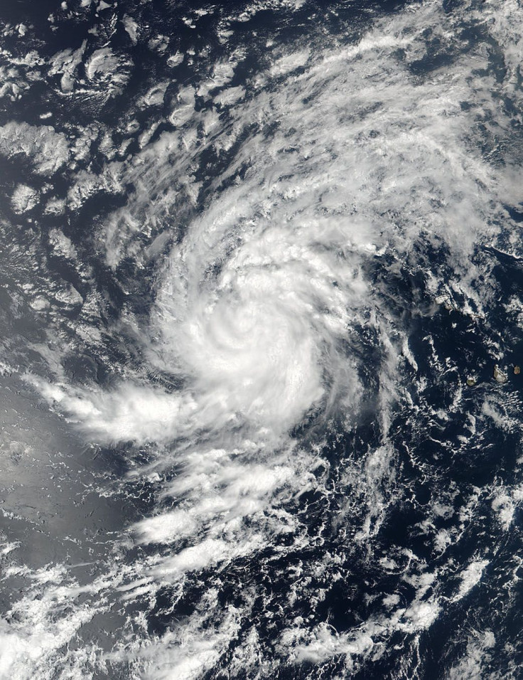
As of Friday evening the storm Irma is classified as a hurricane with maximum sustained wind speeds of 120 miles per hour. It was traveling about 13 mph in a west-northwest direction. But there were no watches or warnings in effect because Irma is still so far out in the Atlantic Ocean.
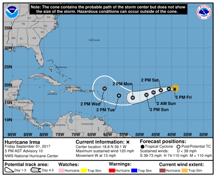
The National Hurricane Center has projected that Irma won’t even get close to islands in the tropics until Tuesday, as the five-day forecast clearly shows.
Fake forecasts were appearing on Twitter, possibly to prey on those worried after seeing the destruction Harvey caused. One fake map showed Irma making landfall in Florida on Thursday evening -- something that didn’t happen -- and then moving up the coast of Florida.
Another tweet and map showed Irma hitting the East Coast near the New Jersey area and said that that the storm would be worse than Hurricane Sandy. Irma is in the tropical Atlantic and it’s impossible to know what it might be like once it reaches the mid-Atlantic and Northeast regions of the country.
One map on Facebook even showed Irma passing Florida and heading right for Texas, the photo got more than 40,000 shares even though it was totally false.
These maps are simply false. Irma’s path as it pertains to landfall is undecided still and days off. It’s difficult for forecasters to know what will happen, meaning any map showing the hurricane hitting the United States within the next few days is probably fake. The National Weather Service even tweeted the latest forecast and advised Twitter users to keep they eyes out for fake forecasts.
Authentic weather forecasts for hurricanes from the NWS look like this.
Keep your eyes out for fake forecasts. THIS is what an official NOAA advisory looks like. Note: forecast only goes out 5 days. #Irma pic.twitter.com/9k87y7jkMz
— National Weather Service (@NWS) September 1, 2017
If you think a map you’re looking at might be fake, you can always check for the real forecast at on the NWS website. There are also several weather apps you can use to track hurricanes and other storms.
NASA is also monitoring Hurricane Irma with its satellites. Images take from above Earth show that Irma is strengthening and organizing itself more like a hurricane, but it's still out over the Atlantic where it's dropping plenty of rain.
The most NHC forecasts in advance is five days. So until Irma gets closer to making landfall, probably around Monday or Tuesday there won't be a forecast showing how it might impact Florida or the Caribbean and Gulf. From there NHC and NOAA will be able to further track the storm and make stronger predictions.
© Copyright IBTimes 2024. All rights reserved.
-

Ukraine, Israel, TikTok: The Massive Aid Package Before US Congress
-

Eiffel Tower Loses Sparkle For Parisians Ahead Of Olympics
-

Former Number One Momota Retires From International Badminton At 29
-

Why Insurance Prices Have Skyrocketed
-

World Bank Aiming To Connect 250 Mn Africans To Energy Grid By 2030
-

IMF Says Global Debt Levels Face 'Great Election Year' Risk
-

Divisions Among Colombia's FARC Dissidents Complicate Peace Talks
-

French Far Right Gets Youthful Vibe With 28-year-old Leader
-

US Fed's Powell Says Inflation Fight May Take 'Longer Than Expected'
-

Mideast-related Oil Price Spike Threatens 'Relatively Good' Economic Outlook: IMF Chief Economist


