

NOAA Interactive Harvey Map Shows Flooding And Damage Across Texas
Even before Hurricane Harvey made landfall there were aerial images of the storm over the Gulf of Mexico threatening the United States with huge white clouds that promised to drop feet of rain.
The images taken from satellites and by astronauts on the International Space Station made the rounds and helped show how strong the storm had the potential to be. Now aerial photos are online of the damage the storm caused available in the form of an interactive map on the National Oceanic and Atmospheric Administration’s website.
Cameras outside @Space_Station captured views of Hurricane #Harvey2017 at 5:15pm ET Aug 25. Updates: https://t.co/vZyAOTUm85 pic.twitter.com/BjDuhOjHSJ
— NASA (@NASA) August 25, 2017
Over the weekend and in the days following, the hurricane dropped record rainfall across the state of Texas and then moved on to Louisiana after that. The bayous spread across Houston overflowed pushing thousands from their homes and causing 30 confirmed deaths so far. Roadways flooded and rescue efforts had to be conducted via air or boat.
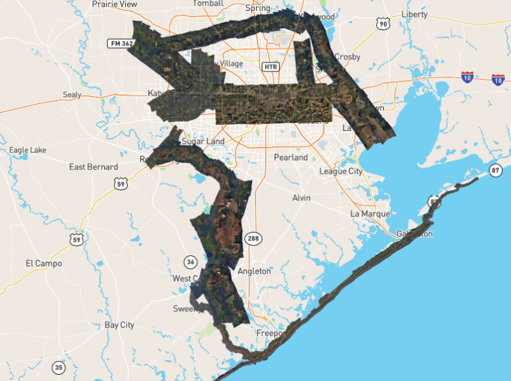
The rain has stopped falling and the clean up effort has begun but it will likely take Texas years to recover from the damage inflicted by Harvey. The current damage can be seen via the interactive map created by NOAA.
The data that is superimposed on the map was collected by the Remote Sensing Division at NOAA to support security and emergency response efforts, said a notice on the site. The map is made up of individual images all combined into a mosaic to create the look of full geographic satellite imaging. Collection of the photos began on Aug. 27 and continued in the following days.
The map does not cover all of Texas, but covers much of the areas devastated by the storm and it can be difficult to tell what exactly is in the photos because of the amount of destruction. Those areas include Houston proper and some of the areas around it as well as Galveston and Padre Island off the coast.
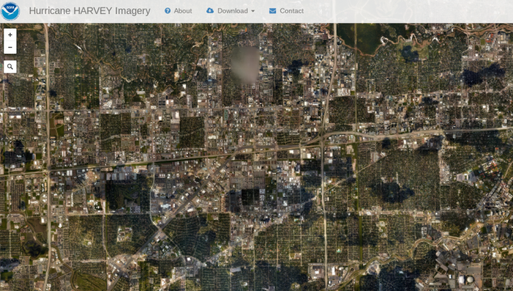
The map has a search feature built in for certain addresses or areas hit by Harvey so users can see their specific neighborhoods or parts of the cities and towns hit. Flooded areas have a blue layer on top of them and the darker blue indicate areas where the water is deeper.
Knowing which roads to avoid can be key. Remember, flooded roads and homes can pose health risks. Not only can the flood water transmit disease and cause infection, animals have been displaced by the storm and flooding and could pose a threat. Additionally down power lines and other structural damage could cause serious injury and death.
© Copyright IBTimes 2024. All rights reserved.
-

IMF Says Global Debt Levels Face 'Great Election Year' Risk
-

Divisions Among Colombia's FARC Dissidents Complicate Peace Talks
-

French Far Right Gets Youthful Vibe With 28-year-old Leader
-

US Fed's Powell Says Inflation Fight May Take 'Longer Than Expected'
-

Mideast-related Oil Price Spike Threatens 'Relatively Good' Economic Outlook: IMF Chief Economist
-

Wine Growers 'On Tip Of Africa' Race To Adapt To Climate Change
-

Despite Olympic Truce, Games Wrestle With Political Fallout
-

What Will The Fed Do With The Latest Inflation Numbers?
-

US Retail Sales Up More Than Expected In March
-

Alexandre De Moraes: Brazil Judge In Feud With Elon Musk


