

California Weather: Forecaster Warns Atmospheric Rivers Could Get 'Ugly'; Flood Watches Issued

KEY POINTS
- Weather officials are concerned about the heavy rain pushing down snow piles from high areas
- Most of the snow piles are expected to melt by Friday afternoon
- Creeks and streams in the Sierra Nevada foothills are most vulnerable to flooding
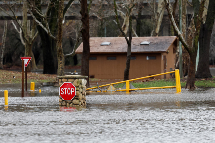
California will once again be drenched in heavy rain, as forecasters warned of back-to-back atmospheric rivers that will hit the state from Thursday through early next week. A forecaster said the first atmospheric river could cause a "really ugly" situation in the state due to the mix of heavy rain and melting snow.
The first atmospheric river is expected to enter California Thursday, Weather Prediction Center (WPC) forecaster Bob Oravec said, while the second one is expected to hit the state Monday, the New York Times reported. Weather officials are especially concerned about areas that already received lots of snow such as low elevations in the Sierra Nevada foothills.
National Weather Service (NWS) meteorologist David Rowe said the situation "could get really ugly," adding that most of the melt was expected in the foothills, as per SF Gate.
"The snowpack is so deep in the higher elevations, even though we're expecting a lot of rain, it will probably soak right in at the higher elevations," he added.
Rowe further explained that piled-up snow is likely to be drenched in warm rain in the coming days and most of the snow below 4,000 feet could melt by Friday afternoon.
"You're going to have water running down the roads, the drains could be clogged," he warned.
Oravec echoed Rowe's sentiments, stating that flooding "is definitely a concern as we go forward" due to heavy rain prompting a lot of snowmelt.
Forecasters are expecting up to 7 inches of rain in some areas across portions of northern and central California by the end of the weekend.
The potential for "significant avalanche danger above 5,000" feet is high, as per the NWS in Los Angeles. The office also urged residents in mountainous areas to protect their properties from flooding.
Here's what we are expecting for the upcoming storm. Looking at 4-8" poss for the San Luis Obispo Coast/foothills, 2-4" for the rest of SLO and Santa Barbara Co. This will be much warmer than the previous storms, so rain will likely fall on snow. #socal #cawx #CArain #SLOweather pic.twitter.com/oS2XVy9l7o
— NWS Los Angeles (@NWSLosAngeles) March 7, 2023
The WPC said creeks and streams in the Sierra Nevada foothills "will be most vulnerable to flooding from rain and snowmelt."
A storm arriving Thursday will bring a threat of flooding from a combination of heavy rain and snowmelt to lower elevations and foothills in California, especially below 5000 feet. And heavy, wet snow at higher elevations will lead to difficult travel and impacts from snow load. pic.twitter.com/TMlr8Ev0tA
— NWS Weather Prediction Center (@NWSWPC) March 8, 2023
Four rivers are currently being monitored, as there is a potential they could exceed flood stage, the NWS in Bay Area said.
"Prepare NOW! The Big Sur and Carmel Rivers are fcst to rise into Monitor Stage Thursday night and Friday, respectively. Big Sur is fcst to reach Flood Stage Friday morning. There is a 20-25% chance of the Carmel River exceeding the 8.5 ft flood stage," it said in a tweet.
Prepare NOW! The Big Sur and Carmel Rivers are fcst to rise into Monitor Stage Thursday night and Friday, respectively. Big Sur is fcst to reach Flood Stage Friday morning. There is a 20-25% chance of the Carmel River exceeding the 8.5 ft flood stage. #Flood #preparenow #CAwx pic.twitter.com/UQ43NEgMZL
— NWS Bay Area 🌉 (@NWSBayArea) March 8, 2023
In a separate post, it noted, "Prepare NOW! The Salinas River near Bradley is forecast to rise into Monitor Stage Friday night and reach Flood Stage early Saturday morning. There is a 30-35% chance of exceeding the 14 ft flood stage."
Prepare NOW! The Salinas River near Bradley is forecast to rise into Monitor Stage Friday night and reach Flood Stage early Saturday morning. There is a 30-35% chance of exceeding the 14 ft flood stage. https://t.co/7UA3E9Z2IG#Flood #preparenow #salinasriver #CAwx pic.twitter.com/hZQxbsreER
— NWS Bay Area 🌉 (@NWSBayArea) March 8, 2023
It also issued a warning about the Pajaro River in Chittenden, noting, "Prepare NOW! The Pajaro River at Chittenden is forecast to rise into Monitor Stage (25 ft) around midnight Friday night. There is a 5% chance of exceeding the 32 ft flood stage and a 25% chance of exceeding 28 ft."
Prepare NOW! The Pajaro River at Chittenden is forecast to rise into Monitor Stage (25 ft) around midnight Friday night. There is a 5% chance of exceeding the 32 ft flood stage and a 25% chance of exceeding 28 ft. #Flood #preparenow #pajaroriver #CAwx pic.twitter.com/4e36EzgAED
— NWS Bay Area 🌉 (@NWSBayArea) March 8, 2023
Flood watches have been issued across parts of the state as weather officials continue to monitor the atmospheric rivers.
Flood watch effective from Thursday afternoon through Sunday morning:
- Greater Lake Tahoe Area
- Lassen-eastern Plumas-eastern Sierra Counties
- Mono County
Flood watches effective from Thursday afternoon through 4 a.m. Sunday:
- Parts of Inyo County in southeast California, including eastern Sierra slopes below 7,000 feet and Owens Valley
- Carquinez Strait and Delta, Motherlode, western Plumas County, Lassen Park, Shasta Lake area, northern Shasta County, central Sacramento Valley, mountains southwestern Shasta County to western Colusa County, southern Sacramento Valley and northern San Joaquin Valley
- Frazier Mountain communities, Kings Canyon NP, Yosemite Valley, Kern River Valley, Grapevine, Grant Grove area, Piute Walker Basin, Sequoia NP, upper San Joaquin River, South end of the upper Sierra, Tehachapi and San Joaquin River Canyon
Flood watches effective from Thursday afternoon through 9 a.m. Sunday:
- San Luis Obispo and Santa Barbara Counties of southwest California, especially northern San Luis Obispo County (rain totals of up to 10 inches possible northwest of San Luis Obispo County)
- West Slope Northern Sierra Nevada
Flood watches effective from Thursday afternoon through 4 p.m. Friday:
- Entire San Francisco Bay Area and Central Coast, including Monterey and San Benito Counties
- Central California below 4,000 feet
Flood watch effective from late Thursday night through Friday afternoon:
- Russian River near Hopland (flood stage of 15 feet may be reached early Friday morning)
Flood watch effective from Thursday afternoon through Friday evening:
- Mendocino Coast
Flood watches effective from Thursday afternoon through 10 p.m. Friday:
- Parts of northwest California, including northeastern Mendocino Interior, northern Lake County, northwestern Mendocino Interior, southeastern Mendocino Interior and southwestern Mendocino Interior
- Southern Lake County
Flood watch effective from Thursday afternoon through late Friday night:
- Cuyama Valley, including Salinas, Sisquoc and Santa Ynez Rivers (rain totals of up to 10 inches possible over northwest San Luis Obispo County)
In January, more than 30 areas were placed under flood watch as California experienced a barrage of atmospheric rivers or tropical moisture in the atmosphere. The so-called "rivers in the sky" can bring significant amounts of water vapor "roughly equivalent to the average flow of water at the mouth of the Mississippi River."
© Copyright IBTimes 2025. All rights reserved.
- MOST POPULAR IN National


