

Extreme Weather: Whiteout Conditions In Central US As Powerful Winter Storm Brings Blizzards

KEY POINTS
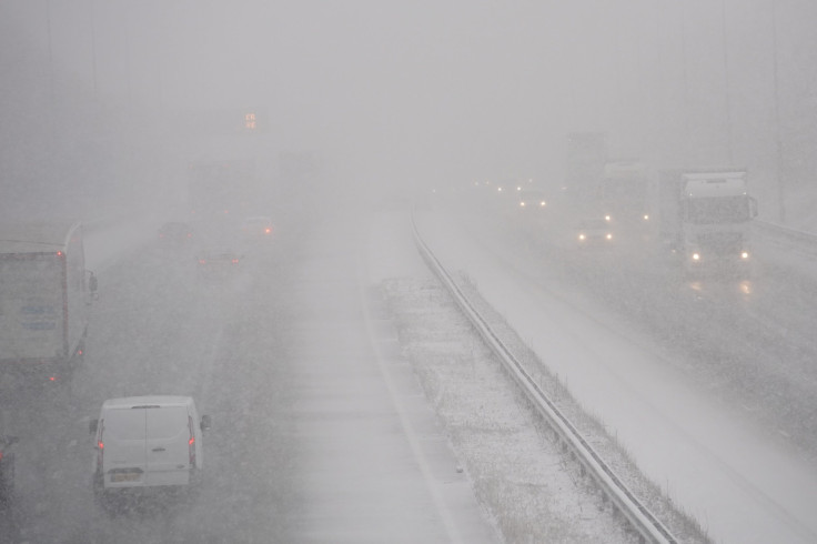
- Whiteouts make travel difficult due to 'no visible' horizons during blizzard conditions
- Wind chills as low as 55 below zero is possible in parts of North Dakota
- Wind gusts as high as 60 mph is possible in some portions of South Dakota
Forecasters are warning of a "tremendously impactful winter storm" that will bring blizzards into the central U.S. and trigger whiteout conditions that could be dangerous for travelers.
"A tremendously impactful winter storm will continue to affect large portions of the nation late this week and going into the holiday weekend. Winter weather hazards will stretch from border to border across the central and eastern U.S.," the National Weather Service (NWS) said in its Short Range Public Discussion report published Thursday.
Much of North and South Dakota have already been placed under Blizzard Warnings, as well as parts of Iowa, Minnesota, and Northeastern Wyoming.
The Weather Prediction Center (WPC) said residents in areas where blizzard conditions occur should also expect "periodic whiteouts with near zero visibility and considerable blowing and drifting of snow."
The ongoing major winter storm will continue to produce areas of heavy snow, strong winds, and life-threatening wind chills through Saturday. If traveling for the holiday, please use extreme caution and pay attention to the latest forecasts and updates. pic.twitter.com/WqMskJosNf
— NWS Weather Prediction Center (@NWSWPC) December 22, 2022
"Traveling in these conditions will be extremely dangerous, to at times impossible," the agency warned.
Whiteout conditions refer to a wintry mix of blowing snow, wind drifts and high winds that result in reduced visibility, according to state-delegated off-road safety information provider Offroad-ed.com. Due to grounds covered in snow, "the landscape may appear entirely white, with no visible horizon," making it difficult to recognize terrain variations.
In North Dakota, the NWS in Bismarck said it is expecting blizzard conditions to last the longest in the southeast part of the state.
Blizzard conditions continue through much of western and central North Dakota. Winds and blowing snow should diminish in the west Friday morning but linger longest in the southeast through the day. Consider delaying travel and check road conditions/closures before leaving. #ndwx pic.twitter.com/1qcVlmkcvh
— NWS Bismarck (@NWSBismarck) December 22, 2022
Officials at the NWS in Grand Forks also noted that many locations will see "dangerous wind chills" as low as 40 degrees to 50 degrees below zero through Sunday, including Cando, New Rockford, Devil's Lake and Forman.
Dangerous wind chills will prevail into Sunday, with many locations getting into the -40s and -50s for minimum wind chills. Combined with blizzard conditions, this makes travel conditions very dangerous this weekend. #MNwx #NDwx pic.twitter.com/BEg2Pka5PZ
— NWS Grand Forks (@NWSGrandForks) December 22, 2022
Over in South Dakota, northwest wind gusts of up to 50 mph should be expected, officials at the NWS in Sioux Falls noted. The highest winds are forecasted to hit Marshall, Lake Andes, Madison, Pipestone, Spencer, Storm Lake and Windom.
Northwest winds gusting at 35-50 mph will persist through Friday evening, and then gradually decrease Friday night.
— NWS Sioux Falls (@NWSSiouxFalls) December 22, 2022
The powdery snow that occurred yesterday is blowing very easily.
Travel will continue to be extremely hazardous, so please stay home and safe in your warm house! pic.twitter.com/H67Ug0xA41
In Minnesota, officials at the Minnesota Department of Transportation strongly discouraged traveling as weather conditions "could be life-threatening" if any travelers are stranded.
🛑 STAY HOME. DO NOT TRAVEL. Most state highways in southcentral & southwest MN are now CLOSED.
— Minnesota Department of Transportation (@MnDOT) December 23, 2022
⚠️ Conditions could be life-threatening if you become stranded.
➡️ https://t.co/yhtPwRwDks for updates + road conditions. pic.twitter.com/Cpm6yN0ePR
The office also said that most state highways have been shut down in southcentral and southwest Minnesota due to extreme weather.
The NWS in Duluth also said power outages are possible through Saturday and dangerous wind chills as low as 40 degrees below zero should be expected.
There's a lot going on across the Northland with winter weather over the next couple days. Let's try to break that down! A 🧵#mnwx #wiwx pic.twitter.com/8lAZGt6KYk
— NWS Duluth (@NWSduluth) December 22, 2022
Officials at the NWS in Des Moines, Iowa, posted similar warnings, noting that wind chill values between 30 degrees and 45 degrees below zero "can produce frostbite in as little as 10 minutes."
⚠️Dangerously cold wind chill values will persist tonight and right through Friday! Values of -30F to -45F are expected! Values this cold can produce frostbite in as little as 10 minutes. A summary of the coldest values - https://t.co/5Ke76KDqv2 #iawx
— NWS Des Moines (@NWSDesMoines) December 23, 2022
Difficult travel conditions will persist tonight. The @iowadot 511 site continues to show most roads partially/fully covered with snow with "No Travel Advised" across much of NW IA. Wind chills remain brutal. Please stay off the roads if at all possible tonight! #iawx pic.twitter.com/BWDE5NUdc3
— NWS Des Moines (@NWSDesMoines) December 23, 2022
Meanwhile, in Wisconsin, the Dodgeville area is expected to get wind chills as low as 39 below zero Thursday night.
Wind chills will drop tonight to around -35 degrees leading to dangerous outdoor conditions. At these wind chills, frostbite may occur on exposed skin in as little as 10 to 15 minutes. pic.twitter.com/NI9ycF3il3
— NWS Milwaukee (@NWSMilwaukee) December 22, 2022
North Dakota
Blizzard Warning effective through 6 a.m. Friday:
- Billings, Adams, Burleigh, Bowman, Emmons, Dunn, Grant, Golden Valley, Hettinger, McLean, McKenzie, Morton, Mercer, Sheridan, Oliver, Sioux, Slope and Stark (wind chills as low as 55 below zero possible)
Blizzard Warnings effective through 6 p.m. Friday:
- Dickey, Foster, La Moure, Kidder, McIntosh, Logan, Wells and Stutsman (wind chills as low as 55 below zero and wind gusts as high as 50 mph possible)
- Barnes, Benson, Cass, Eastern and Western Walsh County, Cavalier, Grand Forks, Eddy, Nelson, Griggs, Ramsey, Pembina, Richland, Ransom, Steele, Sargent and Traill (wind chills as low as 50 below zero possible)
Winter Weather Advisory effective through 6 a.m. Friday:
- Bottineau, Divide, Burke, Mountrail, McHenry, Renville, Pierce, Ward, Williams and Rolette
South Dakota
Blizzard Warnings effective through 5 a.m. Friday:
- Butte, Bennett, Harding, Jackson, Haakon, North Meade Co Plains, Melette, Todd, Tripp, Perkins, Zieback (wind gusts as high as 55 mph possible)
- Pennington Co Plains and Southern Meade Co Plains (wind gusts as high as 60 mph possible)
Blizzard Warnings effective through 5 p.m. Friday:
- Aurora, Bon Homme, Beadle, Brule, Brookings, Charles Mix, Douglas, Davison, Hutchinson, Hanson, Kingsbury, Jerauld, Lincoln, Lake, Miner, McCook, Moody, Minnehaha, Yankton, Sanborn and Turner (wind chills as low as 50 below zero possible)
- Gregory, Clay and Union (wind gusts are high as 50 mph possible)
- Buffalo, Campbell, Corson, Dewey, Hyde, Hughes, Potter, Lyman, Jones, Walworth, Sully and Stanley (wind chills as low as 50 below zero possible)
- Edmunds, McPherson, Hand, Faulk, Brown, Spink, Roberts, Clark, Codington, Marshall, Hamlin, Grant, Day and Deuel
Minnesota
Blizzard Warning effective through 6 p.m. Friday:
- Rock, Clay, East Otter Tail, Norman, West Marshall, West Polk, Wilkin, Kittson, Grant and West Otter Tail (wind chills as low as 50 degrees below zero possible)
Blizzard Warnings effective through 6 a.m. Saturday:
- Pipestone, Murray, Lyon and Lincoln (wind gusts as high as 50 mph possible)
- Cottonwood, Nobles and Jackson
- Big Stone, Traverse, Douglas, Rice, Carver, Scott, Stearns, Todd, Wright, Brown, Chippewa, Lac Qui Parle, Kandiyohi, Redwood, Pope, Renville, Swift, Stevens, Watonwan, Yellow Medicine, Dakota, Blue Earth, Le Sueur, Faribault, Freeborn, Sibley, Meeker, McLeod, Nicollet, Waseca, Goodhue and Steele
- Dodge, Fillmore, Mower, Wabasha, Winona and Houston
Blizzard Warning effective through 8 a.m. Sunday:
- Northern and Southern Cook, Northern and Southern Lake, North Shore (wind gusts as high as 60 mph possible)
Iowa
Blizzard Warnings effective through 6 a.m. Saturday:
- Audubon, Black Hawk, Boone, Butler, Carroll, Calhoun, Crawford, Cerro Gordo, Dallas, Franklin, Greene, Emmet, Grundy, Guthrie, Hamilton, Hardin, Kossuth, Jasper, Marshall, Palo Alto, Sac, Polk, Pocahontas, Poweshiek, Wright, Winnebago, Webster, Worth, Tama and Story (wind gusts of up to 50 mph possible)
- Buena Vista, Cherokee, Dickinson, Ida, O'Brien, Osceola, Benton, Buchanan, Dubuque, Jackson, Decar, Clinton, Delaware, Jones and Linn
- Allamakee, Clayton, Floyd, Chickasaw, Fayette, Winneshiek, Mitchell and Howard (wind gusts as high as 55 mph possible)
Wisconsin
Blizzard Warning effective through 6 a.m. Saturday:
- Trempealeau, Buffalo, Clark, Adams, Juneau, Jackson, Monroe, Taylor and La Crosse (wind gusts as high as 50 mph possible)
- Chippewa, Eau Claire, Dunn, St. Croix, Pepin and Pierce
Blizzard Warning effective through 6 p.m. Saturday:
- Ashland, Bayfield and Iron
Wyoming
Blizzard Warning effective through 5 a.m. Friday:
- Northeastern Crook (wind chills as low as 45 below zero possible)
© Copyright IBTimes 2024. All rights reserved.
- MOST POPULAR IN National


