Great Barrier Reef Dying: NASA Starts Studying Australia's Waters As Part Of 3-Year Mission To Save Reefs

An airborne mission by the National Aeronautics and Space Administration (NASA) is investigating Australia’s Great Barrier Reef. The two-month mission is part of a larger three-year $15 million investigation by NASA’s Coral Reef Airborne Laboratory (CORAL) that aims to better understand the reefs, their health and how to protect them. CORAL’s scientists are expected to assess the existing state of the reefs—which is one the largest reef ecosystems in the world with 2,900 individual reefs scattered across 900 islands.
"CORAL offers the clearest, most extensive picture to date of the condition of a large portion of the world's coral reefs," said Bermuda Institute of Ocean Sciences’ Eric Hochberg, the principal investigator of the project, prior to a briefing at Cairns Airport in North Queensland, Australia. "This new understanding of reef condition and function will allow scientists to better predict the future of this global ecosystem and provide policymakers with better information for decisions regarding resource management."
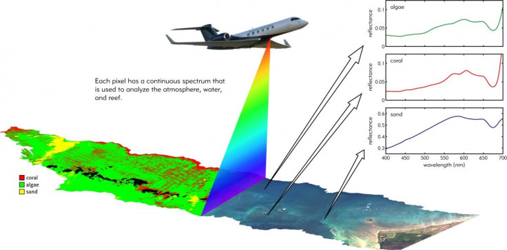
According to Hochberg, NASA will use planes equipped with a state-of-the-art image sensor, called the Portable Remote Imaging Spectrometer (PRISM), that can measure the amount of area coated by coral, sand and algae. Even though the plane will be 23,000 feet above water—this is approximately 10,000 feet lower than where commercial aircrafts fly—the technology behind Prism allows it to gather data from a bird’s eye view with the same level of detail as from a boat.

"The idea is to get a new perspective on coral reefs from above, to study them at a larger scale than we have been able to before, and then relate reef condition to the environment," Hochberg told the Associated Press in June.
The team will then repeat the aerial survey in three other spots, coupling the data with in-water validation activities. One crucial factor in gathering the data is an algorithm that allows researchers to look beyond the water.
“For each reef, the spectral image data are processed to provide the reef “condition” described by measurable quantities of benthic cover of coral, algae, and sand; primary productivity; and calcification,” writes CORAL on its website. “These three reef condition parameters are analyzed quantitatively against ten key biogeophysical parameters using new models to understand reef conditions today and predict reef conditions in the future.”
Researchers have found reefs to be significantly impacted by global warming. Over the past few decades, said the 2015 International Society for Reef Studies Consensus Statement, up to half of coral reefs have been "largely or completely degraded by a combination of local factors and global climate change."
“Our current surveys, even though we’re doing our very best, it’s easy to miss things,” Hochberg told The Guardian. “You look at a point here and a point there but what’s in between? What we’re after is to get the complete picture.”
The broader idea behind CORAL’s mission is to solve the problem of inconsistent data by gathering uniform data with samples.
"Very little of Earth's reef area has been directly surveyed," said Hochberg. "More importantly, there are no existing models that quantitatively relate reef conditions to the full range of biological and environmental factors that affect them—models that can help scientists better understand how coral reefs will respond to expected environmental changes."
The aerial surveys will be taken across the Pacific Ocean. Thus far, the team has surveyed has completed test flights over Hawaii’s Kaneohe Bay. After surveying the Great Barrier Reef in Oct., the team will head to two Hawaiian islands: Palau and Marianas islands. In Australia, the survey will gather data from six regions.
"The Great Barrier Reef is Australia's national treasure, so having a broader understanding of its condition and what's threatening it will help us better understand how we can protect it," said Tim Malthus, research leader of CSIRO's Coastal Monitoring, Modeling and Informatics Group in Canberra, Australia. "Along with surveying several large sections of the reef, CORAL will also survey the health of corals in the Torres Strait, a complex high-tide area that has been historically less studied. It is also opportunistic for us to see if the reef is recovering after the recent bleaching event."
© Copyright IBTimes 2024. All rights reserved.


