Hurricane Irene: Batters Bahamas, Aims at New York Area

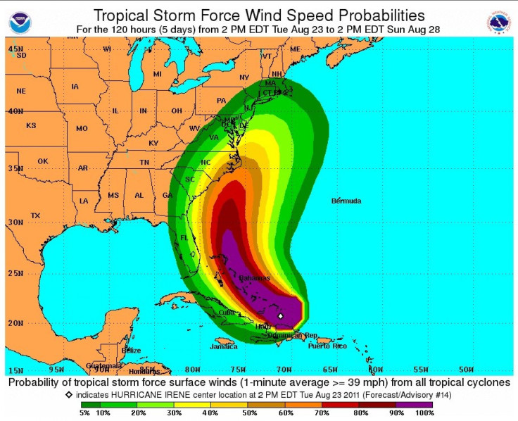
Hurricane Irene became a major storm on Wednesday, upgraded to Category 3 as it battered parts of the Bahamas with 115-mile-per hour winds and took aim on the New York area. Forecast models show a high threat level for eastern North Carolina to New England, and models showed Long Island holds potential for a direct strike.
The massive storm, the first of the 2011 Atlantic hurricane season, could gain strength as it moves up along the U.S. East Coast before possibly striking the New York area late on Sunday at hurricane strength.
It may get a little stronger over the next day or two, said Dennis Feltgen, a spokesman for the National Hurricane Center, in the New York Times.
Already on Wednesday some North Carolina coastal communities were evacuating ahead of the storm. A state of emergency was declared for Hyde County, on the southern half of North Carolina's Outer Banks.
Uncertainty remained about the storm's path on Wednesday but as forecast models showed high probability for a strike in the dense population corridor along the east coast's I-95, attention turned to advising residents to be aware of developments, since the storm holds the potential for torrential rainfall, flooding, high winds and power outages into the weekend.
Early Wednesday, Hurricane Irene was upgraded to a Category 3 storm -- moving it into the major storm grouping.
Hurricane Irene was over the southeastern Bahamas Wednesday morning, moving at nine miles per hour. Tide levels in the Bahamas could reach as high as 11-feet above normal, officials said, with a high storm surge creating dangerous waves near the coast.
No hurricane has made landfall in the U.S. since Ike hit Texas in 2008.
Irene is likely to approach southeast Virginia on Saturday night before moving just off the New Jersey shore on Sunday. Hurricane Irene could make landfall on Long Island or in southeast New England late Sunday afternoon or Sunday night.
Heavy rain, pounding surf, rip currents and strong winds are expected along the the coast into New England as the storm approaches and passes.
This is a good time to get prepared again in your homes. There's items that you should stock up on, those that need to move or possibly be evacuated, perhaps seniors should think about having their medications refilled and having enough on hand, Nassau County Executive Ed Mangano told CBS New York.
On Tuesday, New Yorkers were shaken by an earthquake registering 5.8. A U.S. Geological Survey geophysicist said an earthquake of that magnitude is rare for the East Coast. There are fault lines throughout the East Coast, but typically quakes in the region are shallow.
Thus, while it was a significant shake, damage from the quake was mostly confined to the epicenter, in the Virginia and Washington areas.
I thought I was having a nervous attack, said one employee of a Manhattan cafe, describing how the earthquake felt.
Irene has the potential to be a serious and multiple-hazard threat for New York, with potential for flooding rains, high winds, widespread power outages and down trees and power lines on Sunday and into Monday is very high, authorities say.
Storm paths are always uncertain, but officials are already warning New York area residents to be on alert.
But before Irene reaches New York, the powerful and strengthening storm could wreak havoc as it makes its way up the East Coast. The threat level for the east coast of Florida has been decreased to low as it looks like the Sunshine State got off easy this time, as the storm plows toward the Carolinas.
Forecasts show Irene could clip the Outer Banks of North Carolina by late Friday as a Catogory 3 storm packing maximum sustained winds of up to at least 120 miles per hour.
© Copyright IBTimes 2024. All rights reserved.


