

Kyburz Caldor Fire Grows To 104,000 Acres, Shuts Down Highway 50: Evacuation Orders, Warnings Issued

KEY POINTS
- The Caldor Fire’s size has grown to 104,309 acres
- A highway was shut down and remains closed due to the fire
- The fire burned down Grizzly Flats Community Church as well as the area’s post office
- Nine national forests have been closed due to the Caldor Fire
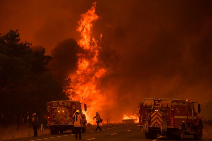
California’s Caldor Fire has consumed more than 104,000 acres, triggering evacuation warnings and orders as Highway 50 remains shut since it was closed Friday.
In a Sunday evening update, CAL Fire said the blaze has grown to 104,309 acres and threatens 13,000 structures following its destruction of more than 320 structures in Northern California, CNN reported. Since it became a fire of interest when it broke out in El Dorado County more than a week ago, the Caldor Fire is only 5 percent contained as of now.
Dustin Martin, a unified incident commander overlooking the Caldor Fire, said the blaze grew due to increased wind activity in the area. The fire has since been pushed to the east and approached Kyburz on Saturday.
The Caldor Fire in Northern California has grown to nearly 100,000 acres in little over a week and remains 0% contained. It's one of 94 large fires burning across 12 US states.https://t.co/g2S1mDfiUh
— CNN Breaking News (@cnnbrk) August 22, 2021
As for Highway 50, which is located between highways 50/89 in Meyers and Sly Park Road, Martin said it won’t be reopened anytime soon due to safety worries, local radio station KXJZ reported. With the fire burning close to the highway, tree hazards are possible and could cause dangers to the public.
NEW: Highway 50 will close soon due to the #CaldorFire. https://t.co/2CwyOMLgXa
— Heather Janssen (@Heather_Janssen) August 20, 2021
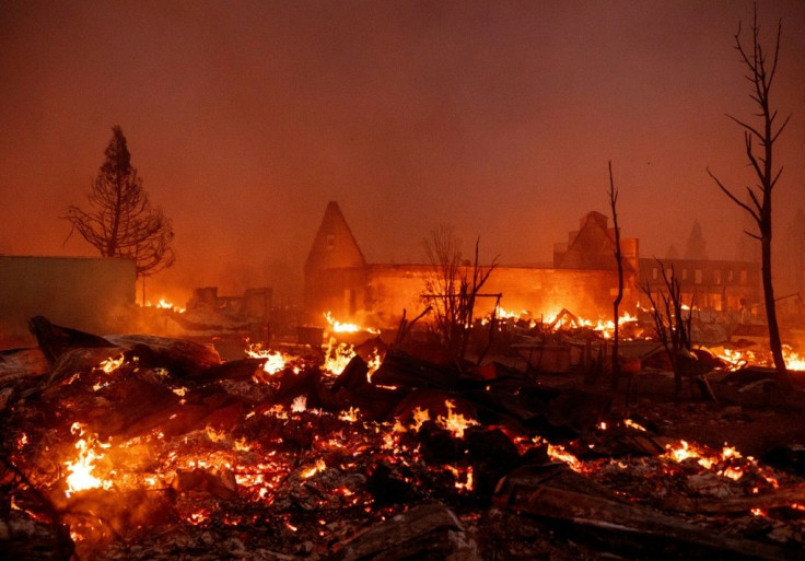
Among the properties turned into rubble by the Caldor Fire in the Grizzly Flats area was the post office and the Grizzly Flats Community Church, the Los Angeles Times reported. The remnants of the church were some skeletons of chairs, the foundation, and several twisted metals. Only a wheelchair ramp could be seen as the remaining part of the wiped-out post office. Around 13,114 structures are still threatened by the blaze.
Evacuation orders around Kyburz have been released over the past few days, including a new evacuation order issued for areas east of Bridgeport School road to the Amador County line as well as those south of Farnham Ridge Road. There are a few homes in the said rural areas but the El Dorado County Sheriff’s Office said the order was necessary for “mapping technicality” purposes.
The following areas have been issued with evacuation warnings due to the Caldor Fire:
- East on Fiddletown Road to Hale Road
- Shenandoah Road through the River Pines Community
- Tiger Creek Road east
- Salt Springs Reservoir Road
- East on Shake Ridge Road to Charleston Road
- Ostrom Road south to Jibboom Streeet
- West of Jibboom Street to Fiddletown Road
- Eastern border of the Alpine County line
- Southern border of the Calaveras County line
#RT @CAL_FIRE: RT @CALFIREAEU: El Dorado County Evacuation Order Update: 8/21/21 #caldorfire @ElDoradoSheriff @EldoradoNF pic.twitter.com/seLptGm3Ej
— CAL FIRE PIO (@CALFIRE_PIO) August 21, 2021
The following areas have been issued with evacuation orders:
- Areas around Grizzly Flats Road east of Kendra Way into Grizzly Flats Proper
- Myers Lane, Rodwell Canyon Road, Mehwald Lane, Varmet Ridge Road, and Snowbird Lane
- North of Highway 50
- East of Forebay Road and Fresh Pond
- East of Four Corners in Somerset into Grizzly Flats Proper
- All roads off of Omo Ranch
- All roads off of Slug Gulch
- East side of Fairplay Road from Perry Creek South to Cedarville Road
- Silver Fork Road in Kyburz east to Twin Bridges
- Between Highway 50 and Slab Creek
Aside from evacuation orders, the U.S. Forest Service also said nine national forests, including the Klamath National Forest, Six Rivers National Forest, and the Shasta-Trinity National Forest, will be closed from Sunday evening through Sept. 6 as part of the efforts to prepare for potential fire growth, NBC affiliate KCRA-TV reported.
More than 1,600 personnel and volunteers are fighting on-ground to stop the Caldor Fire from burning further. Last week, two people were seriously injured while battling the flames.
Meanwhile, the Dixie Fire, the nation's largest active wildfire and the second largest in California history, has grown to 724,110 acres, according to CAL Fire's update Sunday evening. The fire that started in mid-July is now 38% contained.
© Copyright IBTimes 2024. All rights reserved.
- MOST POPULAR IN National


