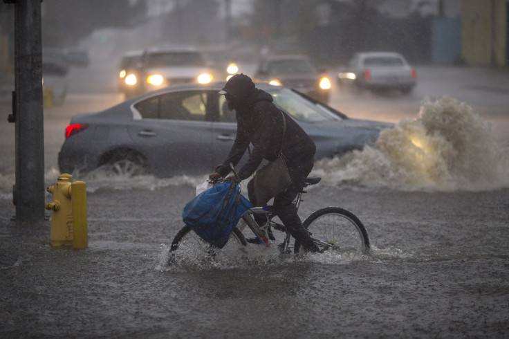
Minnesota Storm Damage: Power Lines Down, Faribault Airport Flooded

Severe storms and multiple tornadoes tore through Southern Minnesota, causing widespread damage Thursday night.
@ian_leonard Faribault Airport pic.twitter.com/nFsDBT2sd0
— ❌Thoughts & Prayers❌ (@trollbaitclick) September 21, 2018
Reports said significant damages were reported at the Faribault Municipal Airport, flipping airplanes and flattening hangers. Heavy rain in the area left the airport flooded with water. Trees and power lines were knocked down due to strong winds in Waterville. According to reports, there was no power in the area.
A map on Xcel energy showed that 25,018 people were without power in Minnesota on Thursday, with 8,798 of them from Rice County.
A preliminary listing of wind damage and tornado reports from southern Minnesota this evening. Sounds like the NWS damage survey team is already in action in the hardest hit areas. #MNweather pic.twitter.com/xDuSAATfxW
— Joshua Jans (@joshuajans) September 21, 2018
Multiple tornados were reported in Waterville, Dundas/Northfield area, north of Faribault, West Concord and Granada. The official number of tornadoes will be confirmed and published by the National Weather Service (NWS) after completion of damage surveys by the crews.
Tornado passing through Granada, MN in the past hour.
— Tanner Verstegen (@VerstegenWX) September 21, 2018
Posted with permission from my bud @JeffWetterlin. @NWSTwinCities #Tornado pic.twitter.com/EARDeXRhWf
So far, there were no reports of injuries or causalities, an official in the Le Sueur County Sheriff's Office dispatch center said.
A Christian camp in Waterville, Camp Omega, reported "severe damage" at its campgrounds. Its members said there were at least eight trees that fell down due to storm, blocking the main road and asked for volunteers to bring chainsaws to remove the blockage on Friday.
“Attention, due to the tornado that swept through the grounds, we are asking for safety reasons that everyone stay clear of the campground until further notice,” they said. “Please do not call. Power is out. Please pray for Waterville.”
Places like Faribault, Waterville, Mapleton and Red Wing received the maximum damage with many buildings getting damaged and destroyed due to storms.
Just got to #Waterville, TONS of damage #mnwx @KSTP pic.twitter.com/HqObyja8jv
— Brett Hoffland (@BrettHoffland) September 21, 2018
Waterville, MN pic.twitter.com/ybAKirVUVx
— Katie Purington PhD (@katepurington) September 21, 2018
Earlier in the day, the NWS issued tornado warnings for Goodhue, Dodge, Dakota, and Rice Counties.
“Please seek shelter if you are in Goodhue and southern Dakota counties. These storms have a history of producing tornadoes,” the agency warned.
Major flooding in Robbinsdale!
— Mary McGuire (@mcguirereports) September 21, 2018
📸: Amanda Lemke #MNwx pic.twitter.com/DufR6gTXZQ
"Anyone with street flooding concerns should report directly to 911 so calls can be prioritized," a Facebook post from the City of Robbinsdale where flooding was reported, read. "There are water issues all over. We can try to keep cars from driving into water and getting stalled."
Flood warnings for areas in the twin cities of Minneapolis and St Paul were effective till 9 p.m. local time (10.00 p.m. EDT). Heavy rain and flooded streets were reported in the metro area.
Tornado watches were issued for Northeast Iowa, Southeast Minnesota, and Western and central Wisconsin. It will be effective till 12.00 p.m. CDT (1.00 a.m. EDT, Friday). The report said a couple of tornadoes were possible in the area along with scattered damaging winds with isolated gusts of up to 75 miles per hour. It said air traffic in the area should look out for a few severe thunderstorms with hail.
A report by Fox 9 said winds reached more than 60 miles per hour from 5:30 p.m. to 7 p.m. CDT Thursday (6.30 p.m. to 8 p.m. EDT).
A day two outlook on the thunderstorm by NWS noted there was a slight risk of thunderstorms across Ohio, Pennsylvania, New York, and Vermont. The report said scattered thunderstorms with wind gusts capable of damage might affect parts of Ohio Valley on Friday.
© Copyright IBTimes 2024. All rights reserved.


