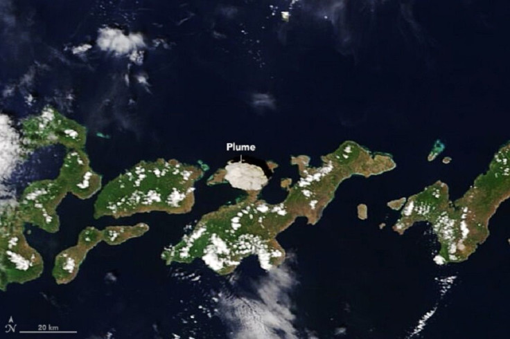
NASA Satellite Image Captures Eruption Of Indonesia's Lewotolo Volcano
KEY POINTS
- Indonesia's Lewotolo volcano erupted on Sunday, spewing ash and smoke into the air
- A NASA Satellite captured an image of the thick plume soon after the eruption
- Just this week, another volcano in Indonesia also showed signs of activity
A NASA satellite captured the powerful eruption of Indonesia's Lewotolo volcano on Sunday. It now adds to the long list of volcanic eruptions in the country this year.
Two days after it began showing signs of mild activity, Indonesia's Lewotolo volcano in Lembata regency, East Nusa Tenggara erupted on Sunday. It spewed a plume of volcanic ash and smoke some 4,000 meters into the air at 9:45 a.m. local time, The Jakarta Post reported.
Just a few minutes later, the Moderate Resolution Infrared Spectroradiometer instrument on NASA's Terra satellite captured an image of the eruption, showing the thick, white plume over the island. In the image, shared by NASA Earth Observatory, one can clearly see the thick plume of ash and smoke practically covering a portion of the island.

According to NASA Earth Observatory, the plume was so high that authorities had to close the local airports and issue an aviation warning as ash had rained down on many parts of the island. The Jakarta Post also reported that apart from the plume, the volcano released volcanic material "as big as coconuts."
As of Monday, the United Nations Office for the Coordination of Humanitarian Affairs reported no injuries related to the eruption. However, thousands of residents have since been forced to leave their homes.
2020 Volcanic Eruptions In Indonesia
As the Jakarta Post explained, this is only one of several volcanic eruptions in Indonesia this year. In April, Mount Anak Krakatau in Lampung and Mount Semeru in East Java erupted on the same day. In August, Mount Sinabung in North Sumatra also spewed ash and smoke several times.
Only recently, Mount Merapi in Magelang Central Java also erupted, forcing thousands to flee their homes, the outlet said.
This Tuesday, just days after Lewotolo's eruption, Indonesian authorities also evacuated residents of several villages around Mount Semeru in Lumajan District after it spewed hot ash down its slopes, Al Jazeera reported.
As the outlet explained, this level of activity is because Indonesia sits on the Pacific Ring of Fire, making it prone to such seismic upheavals. According to National Geographic, 75% of the world's volcanoes lie on the Ring of Fire and some 90% of earthquakes occur along its path.

© Copyright IBTimes 2024. All rights reserved.


