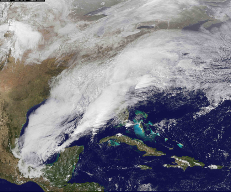
NASA's Thanksgiving 2017 Weather Prediction Shows Storms Brewing On Both Coasts

There has been a furor over metrological activity over the U.S. for the past three months. Hurricanes have ravaged several areas along the U.S coastline. Several satellites are in place to track weather patterns in our atmosphere. Ahead of the Thanksgiving holiday, NOAA’s GOES-East satellite showed two storm systems for pre-Thanksgiving travelers Wednesday, Nov. 22, 2017. One system was exiting the northeastern U.S. while the other was affecting the Pacific Northwest.
According to a press release on NASA’s website, NOAA's GOES-East satellite captured this visible image of the U.S. showing storm systems on the East and West coasts for Thanksgiving travelers. The readings made on Nov. 22 at 10:15 a.m. EST were released as an image which showed clouds in the northeastern U.S. associated with a cold front covering the New England states.
Clouds associated with a system in the Pacific Northwest were seen over Washington State, Oregon, Idaho, Montana, and Colorado.
The report warns travelers who have planned holidays around Thanksgiving travelers to be wary of regions in the northern Plains and Upper Great Lakes as they will witness extreme arctic air that is expected to bring periods of “snow, blustery winds, and cold wind chills”.
The National Weather Service said that light snow is also possible in areas stretching up to New England and the Ohio Valley.
In August, IBTimes reported that Hurricane Harvey shut down completely or partially at least 14 oil refineries which affected gas prices, making them go up as much as 20 cents nationally and as much as 35 cents in parts of Texas and Louisiana. The recent hurricanes are estimated to cause the U.S. government almost $300 billion, according to this IBTimes U.K. report.
NOAA’s National Weather Service Weather Prediction Center (WPC) in College Park Maryland, said that “more heavy rain is expected for the Northwest and another cold front will sweep through the central and eastern states,” in the report.
The predictions also said that on the U.S. West coast, active storm weather will remain north of San Francisco through Thanksgiving. They have chalked this up to persistent onshore flow and deep moisture moving inland from oceans.
WPC also added that this flow will create a heavy rainfall event along and west of the Cascades Mountain range.
WPC warned travelers heading towards western Washington areas saying that the potential for amounts in excess of three inches is possible there. The report added that regions surrounding the northern Rockies are also expected to receive moderate to heavy rain as the moisture continued to move farther inland.
The satellites have estimated that snowfall would be confined to the higher altitudes only, with the weather not severe enough to cause heavy snowfall in areas that lie below the tree line. But, there were warnings and cautions of a possible flood in the Pacific Northwest region. “Some instances of flooding will also be possible across parts of the Pacific Northwest,” added the report.
Southwest regions across the U.S. will see high and dry times during Thanksgiving. Low elevations in the areas of the desert in the southwest will cause an expected rise in temperatures which can go up to 90 degrees Fahrenheit. But, people heading east towards the Rockies will have to brave the very cold weather. A cold front was seen growing here which has been estimated to bring showers and a few thunderstorms across Florida and the southeast over the next couple of days. This cold front will exit the U.S. East Coast on 22 Nov.
© Copyright IBTimes 2024. All rights reserved.


