NY, New Jersey Brace For Impact As California ‘Bomb Cyclone’ Storms Surge East

KEY POINTS
- The bomb cyclone first hit California, led to flooding and cut off power lines that affected thousands
- Governors of the two states declared states of emergencies that started Monday
- Flash flood watches and warnings have been set for several NY and NJ areas
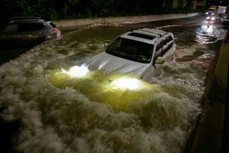
The states of New York and New Jersey are bracing for the impact of a “bomb cyclone” that led to mudslides, flooding, and cut off power of more than 100,000 residences and businesses across California on Monday.
Accuweather meteorologist Joseph Bauer warned that New York City’s commute operations may be affected by heavy rains and winds Tuesday, USA Today reported, while the National Weather Service (NWS) issued a flash flood warning for parts of southeast New York.
Parts of northeast New Jersey are also expected to be affected by thunderstorms. The warnings prompted New York Gov. Kathy Hochul, and New Jersey Gov. Phil Murphy to declare states of emergency that started Monday evening.
With severe weather including heavy rain and high winds expected tonight through Wednesday, I am declaring a state of emergency for counties in the Capital Region, Long Island, New York City, Mid-Hudson and Southern Tier regions.
— Governor Kathy Hochul (@GovKathyHochul) October 26, 2021
Stay safe, New York. https://t.co/BzdT4hUaaN
In preparation for the Nor’easter, I’m declaring a State of Emergency beginning at 8:00 PM tonight.
— Governor Phil Murphy (@GovMurphy) October 25, 2021
Severe weather conditions will impact the state starting tonight through the next several days.
For updates, follow @ReadyNJ, @NWS_MountHolly, and @NWSNewYorkNY. pic.twitter.com/eJlMgt253f
Meteorologists said the bomb cyclone, which is the rapid dropping of a cyclonic low-pressure area, drove a wide plume of atmospheric water vapor into the West Coast. The bomb cyclone is expected to “slowly move eastward across the country.”
In a tweet, Mayor de Blasio asked New Yorkers to “take this seriously.” The state is “expecting 2”-4” of rain tonight and going through Tuesday,” he said. “Use mass transit for your commute tonight and tomorrow. Don’t walk or drive into flooded areas.” Hochul said the “heavy rain” is expected across parts of the state through Tuesday morning.
We're expecting 2"-4" of rain tonight and going through Tuesday. A Flash Flood Watch is in effect from 8PM tonight until 5PM tomorrow. Take this seriously. Use mass transit for your commute tonight and tomorrow. Don't walk or drive into flooded areas. https://t.co/tHJJfe23GH
— Mayor Eric Adams (@NYCMayor) October 25, 2021
We're expecting heavy rain in parts of New York State beginning late tonight and heading into the morning.
— Governor Kathy Hochul (@GovKathyHochul) October 26, 2021
With flash flood watches already in effect, exercise caution during your morning commute. And if there's flooding, remember: turn around, don't drown. pic.twitter.com/Kt7vZmcyw6
NJ Transit also warned that “severe weather” is expected through Tuesday. The company said it is planning “to run regular weekday bus, rail, light rail, and Access Link service for as long as it is safe to do so.”
In his latest tweet, Murphy said the “anticipated Nor’easter is forecasted to bring significant flash flooding, coastal flooding, and wind gusts.” Meteorologists said the bomb cyclone could become a nor’easter. The NWS describes a nor’easter as a storm along the East Coast with winds that typically come from the northeast.
Watches and Warnings in place:
- Paterson, NJ
- Clifton, NJ
- Passaic, NJ
- Northwestern Bergen County, NJ
- Rockland County, NY
- New York City
- Broome, NY
- Chenango, NY,
- Delaware, NY
- Otsego, NY
- Sullivan, NY
- Tioga, NY
The NWS has also projected heavy rainfall across Massachusetts through Wednesday evening. The agency noted that “rainfall totals of 2 to 4 inches with locally higher amounts” could possibly occur.
© Copyright IBTimes 2024. All rights reserved.
- MOST POPULAR IN National