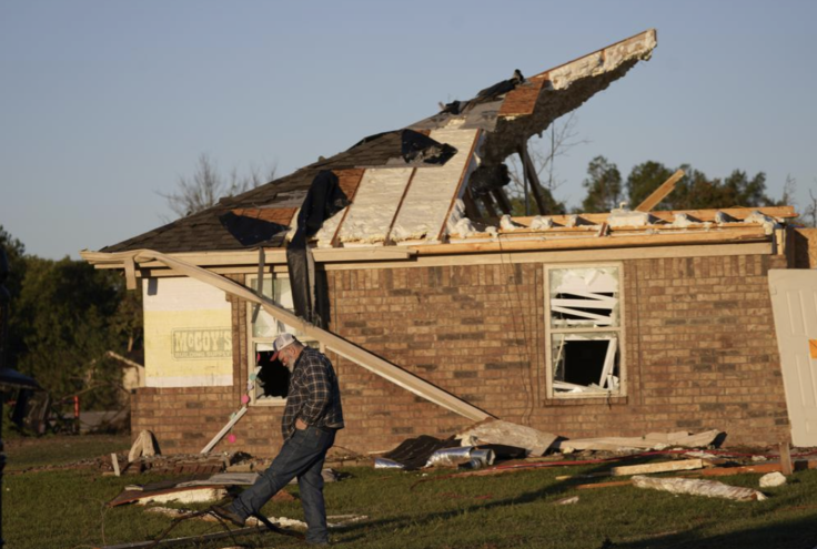
Severe Weather Outbreak Expected In Southern States, Officials Warn Of 'Long-Lived Tornadoes'

KEY POINTS
- Mississippi, Tennessee and Alabama are expected to see tornadoes Tuesday
- Flash flooding is possible in Louisiana and the lower Mississippi Valley
- Weather alerts have been issued in Tennessee, Arkansas and Louisiana
Severe thunderstorms are expected Tuesday in parts of the South, the National Weather Service (NWS) said. Officials said flash flooding is possible in some areas and residents should prepare for the possible appearance of "long-lived tornadoes."
"A Severe weather outbreak which could include strong and long-lived tornadoes is possible across the south tomorrow afternoon and evening," the NWS said in a tweet Monday.
A Severe weather outbreak which could include strong and long-lived tornadoes is possible across the south tomorrow afternoon and evening.
— National Weather Service (@NWS) November 28, 2022
Follow local forecast offices for the latest info.https://t.co/GWrG0hCgjd https://t.co/GZhViZnhUM
The National Oceanic and Atmospheric Administration's (NOAA) National Severe Storms Laboratory (NSSL) said long-lived tornadoes typically last longer than an hour, and one such tornado is a supercell, which is considered a "highly organized storm" that could trigger the formation of "most large and violent tornadoes."
The NWS Storm Prediction Center also said some "(strong/long-track) damaging winds, and hail are all possible" in the lower Mississippi Valley region from Tuesday afternoon through the evening.
There is a Moderate risk of severe weather forecast for tomorrow (11/29) across parts of the lower Mississippi Valley region. Tornadoes (some strong/long-track), damaging winds, and hail are all possible during the afternoon into the overnight. Stay weather aware in these areas. pic.twitter.com/yFw3X77r5z
— NWS Storm Prediction Center (@NWSSPC) November 28, 2022
Flash flooding is possible in the lower Mississippi Valley due to severe thunderstorms, the Weather Prediction Center (WPC) said in its Short Range Public Discussion report published Monday.
In Louisiana, the NWS in New Orleans said flash flooding is a concern "mainly Tuesday night overnight into Wednesday morning." Officials said up to 3 inches of rainfall per hour is likely.
Flash Flooding will be a concern, mainly Tuesday night overnight into Wednesday morning. 1-3 inches total will be possible with locally higher amounts likely. 1-3 inches per hour rainfall rates will be likely as well. Main area of concern is N of I-10/I-12. #mswx #lawx (5/n) pic.twitter.com/E2Zdr8tk3q
— NWS New Orleans (@NWSNewOrleans) November 28, 2022
The NWS in Nashville, Tennessee has also warned of possible large hail and several tornadoes are possible Tuesday evening, with areas "west of I-65" possibly experiencing severe weather conditions.
Severe storms are possible tomorrow evening and perhaps into the overnight hours. The best chance for severe weather will be in areas west of I-65 between 6 p.m. and midnight. Damaging straight-line winds, large hail and even a few tornadoes are possible during this event. pic.twitter.com/RmCNQhZvcX
— NWS Nashville (@NWSNashville) November 28, 2022
Similar weather events are also expected in Alabama, according to the NWS in Huntsville.
[12:40PM] Severe thunderstorms will be possible across the TN Valley from Tuesday night-Wednesday morning ⛈️ Threats include the following:
— NWS Huntsville (@NWSHuntsville) November 28, 2022
💨 Damaging wind gusts
🌪️ Tornadoes
🧊 Large Hail
💧 Locally Heavy Rainfall
Have multiple ways to receive warnings! ⚠️#HUNwx #ALwx #TNwx pic.twitter.com/cQT7kgIcAG
In Georgia, where officials said "20% of the state is in a severe drought," the storm system Tuesday through Wednesday is expected to bring up to 2 inches of rain in "areas that need it most!"
More than 70% of the state of GA is experiencing abnormally dry conditions or worse, and more than 20% of the state is in a severe drought. 😵💫 A storm system moving through Tuesday to Wednesday looks to bring as much as 2" of rain to areas that need it most! 🤞 #gawx https://t.co/cmSlawdyTd pic.twitter.com/hp2XRTFpII
— NWS Atlanta (@NWSAtlanta) November 28, 2022
Meanwhile, a High Wind Watch has already been issued in Tennessee. Officials said widespread power outages are possible in affected areas and damaging winds may down trees.
The following areas are affected by the High Wind Watch effective from Tuesday afternoon through Wednesday morning: Blount Smoky Mountains, Cocke Smoky Mountains, Johnson, Sevier Smoky Mountains, Southeast Carter, Southeast Greene, Southeast Monroe and Unicoi.
A Wind Advisory effective through Tuesday noon is up for Arkansas in the following areas: Washington, Madison, Carroll and Benton.
Weather officials in Louisiana have issued a Flood Warning effective through 6 p.m. Tuesday for the Calcasieu River near Salt Water Barrier.
Officials have not issued similar weather warnings in other southern states but they urged residents to keep track of possible changes in weather alerts and advisories through Wednesday.
© Copyright IBTimes 2024. All rights reserved.
- MOST POPULAR IN National