

Striking Satellite Imagery Shows Parts Of US Shrouded In Canadian Wildfire Smoke

KEY POINTS
- Wildfire smoke from Canada continues to affect parts of the U.S.
- A satellite captured the development of the smoke in the first week of June
- People are advised to monitor the air quality in their areas
Parts of the U.S. have been covered in smoke as Canada continues to battle hundreds of wildfires burning across the country. Satellites watching over the Earth have captured the sheer coverage of the wildfire smoke.
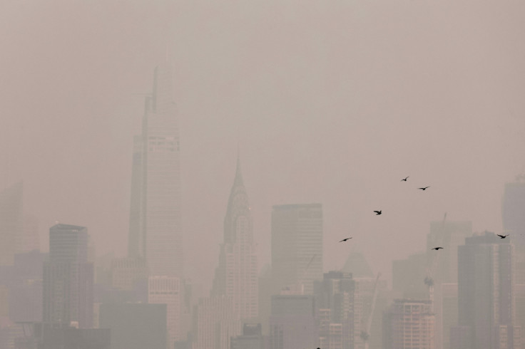
U.S. cities have been covered in toxic haze amid the wildfires in Canada. New York City had the worst air quality in the world Wednesday, with an air quality index of 256, which is considered to be "very unhealthy." Some flights had to be halted, and some areas were shrouded in a hazy, orange-to-reddish hue.
Wildfire smoke from Canada doesn't usually get noticed, according to NASA Earth Observatory. This June, however, the massive fires in Quebec spewed smoke southward into the U.S., which some satellites in space were able to capture.
This week, @NOAA satellites are monitoring even more thick smoke from #wildfires burning in Canada that has been blowing over the eastern and central U.S., triggering air quality alerts in many areas.
— NOAA Satellites (@NOAASatellites) June 8, 2023
Learn more in our latest #EarthFromOrbit video: https://t.co/zjwQ82xPFN pic.twitter.com/8goFTTx7x3
In an image shared by the agency, the smoke billowing over the U.S. is so thick that one could barely see the ground below. It was captured by NASA and the National Oceanic and Atmospheric Administration's (NOAA) GOES-16 satellite and showed the wildfire smoke covering New York and Pennsylvania.
Fires in Quebec have delivered one of the most intense outbreaks of smoke seen in the eastern U.S. in decades.
— NASA Earth (@NASAEarth) June 8, 2023
This image from @NOAA’s GOES-16 shows smoke sweeping into New York and Pennsylvania on the morning of June 7.
🔗 https://t.co/Rr2dkIHeDz pic.twitter.com/V2Y2VxZq1Q
"Winds typically move smoke from fires in Quebec toward the east and out to sea. But in June 2023, a persistent coastal low centered near Prince Edward Island instead steered smoke south into the United States," NASA Earth Observatory explained.
Though most of the smoke that reached the northeastern U.S. was still at high altitudes, because of its close proximity to Quebec, "a much larger proportion" of it was at surface level too.
Another striking imagery of the wildfire smoke comes from the NASA/NOAA satellite Suomi-NPP. Here, one could see the development of the smoke in the first week of June. Starting from June 2, when the smoke was somewhat visible but still not quite as extensive, the imagery shows how it gradually grew until June 7 when it was already quite thick.
An unusually active early fire season in Canada lofted smoke across swaths of the eastern U.S., seen here by the @NASA/@NOAA Suomi-NPP satellite.
— NASA Earth (@NASAEarth) June 8, 2023
Data from NASA and NOAA satellites contribute to air quality monitoring systems to help track unhealthy air pollution. pic.twitter.com/7EvBuVHdBs
The National Weather Service Weather Prediction Center is expecting a gradual improvement of the smoke conditions across the U.S. as it moves offshore. However, they will still be at "unhealthy levels" in some areas, and there's also the possibility of more smoke coming in.
Air quality will continue to slowly improve this afternoon, albeit remaining at unhealthy levels along the I-95 urban corridor, as smoke from the Canadian wildfires moves southward & offshore. However, another surge of smoke will be possible in PA and the Mid-Atlantic overnight. pic.twitter.com/WrmMZqMBDP
— NWS Weather Prediction Center (@NWSWPC) June 8, 2023
People are being advised to stay up-to-date on the air quality reports in their areas.
They should take important steps to protect themselves from the potentially hazardous impacts of wildfire smoke, like keeping the air indoors clean. People should avoid activities that may aggravate the pollution such as lighting candles and vacuuming.
© Copyright IBTimes 2024. All rights reserved.
- MOST POPULAR IN Science


