Tropical Storm Dorian 2013: Path To Follow Across Atlantic Ocean, Could Land In Bahamas As Early As Next Week [PHOTO]

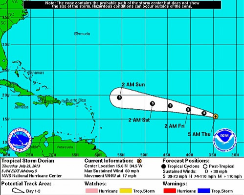
The latest advisory out of the National Hurricane Center in Miami indicates that Tropical Storm Dorian is gaining strength as it makes its way across the Atlantic on a westward path that may take it into the Caribbean Sea.
Dorian was last spotted by the NHC about 700 miles west of the Cape Verde Islands and moving west-northwest at 17 mph with maximum sustained winds of 60 miles (95 kilometers) per hour.
Despite the center forecasting little change in Dorian’s strength for the next 48 hours, Stacy Stewart, a senior specialist there, told Bloomberg there is a good chance the weather system will continue to move west. Forecast maps, which project only five days ahead, show it tracking north of Puerto Rico or over the island by Monday.
While Dorian doesn’t currently pose an immediate threat to the U.S. mainland, if it stays on track, there’s a possibility it may bring wind and rain to the southern United States or the Bahamas early next week.
"It does have some hoops to fly through,” Michael Schlacter, founder and president of Weather 2000 Inc., told Bloomberg. “If we get past 96 hours and it’s still some sort of system, then all of a sudden things will start to become clear to people. There’s a built-in risk of an anticlimax here because it is off of Africa. We have a long, long time to watch this.”
The Gulf of Mexico is home to about 6 percent of U.S. natural gas output, 23 percent of oil production and more than 40 percent of petroleum refining capacity, according to the Energy Department.
In related news, Tropical Storm Flossie formed far out over the Pacific. Flossie's maximum sustained winds are near 40 mph (65 kph) with slow strengthening expected over the next day or so. The storm is centered about 1,045 miles (1,685 kilometers) west-southwest of the southern tip of Mexico's Baja California and is moving west-northwest near 15 mph (24 kph).
© Copyright IBTimes 2024. All rights reserved.


