Tropical Storm Ophelia Strengthens Overnight [PATH & MAPS]
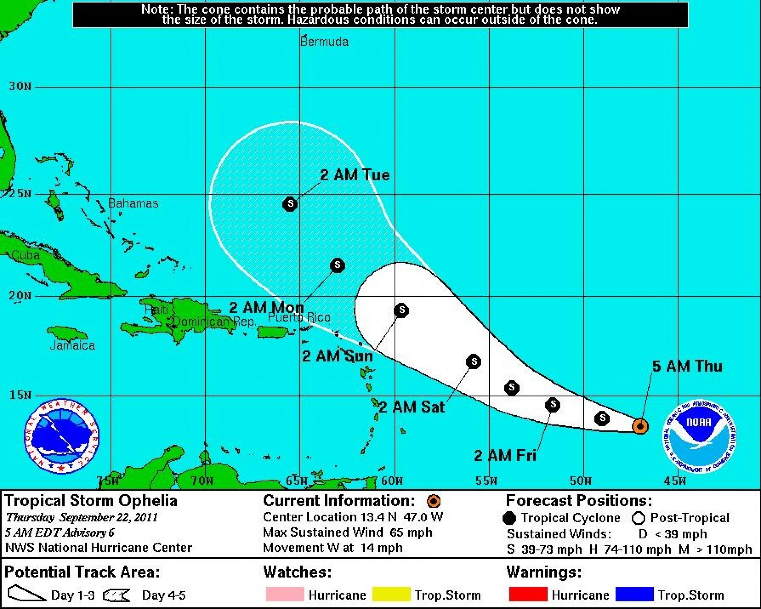
Tropical Storm Ophelia intensified overnight as it churned away in the tropical Atlantic. On its constantly changing path, the storm is expected to curve north of the Leeward Islands and be located halfway between Puerto Rico and Bermuda by Tuesday morning.
The 15th named storm of the 2011 Atlantic hurricane season, meteorologists at the National Hurricane Center (NHC) in Miami have tracked Ophelia since Friday afternoon when it emerged as a low pressure system in association with a tropical wave several hundred miles to the southeast of the Cape Verde Islands.
The storm gained momentum early on in the week.
The low over the Tropical Atlantic has finally coalesced about a single circulation center and has enough organized deep convection to be considered a tropical cyclone, Michael Brennan, NHC senior hurricane specialist, said on Tuesday evening.
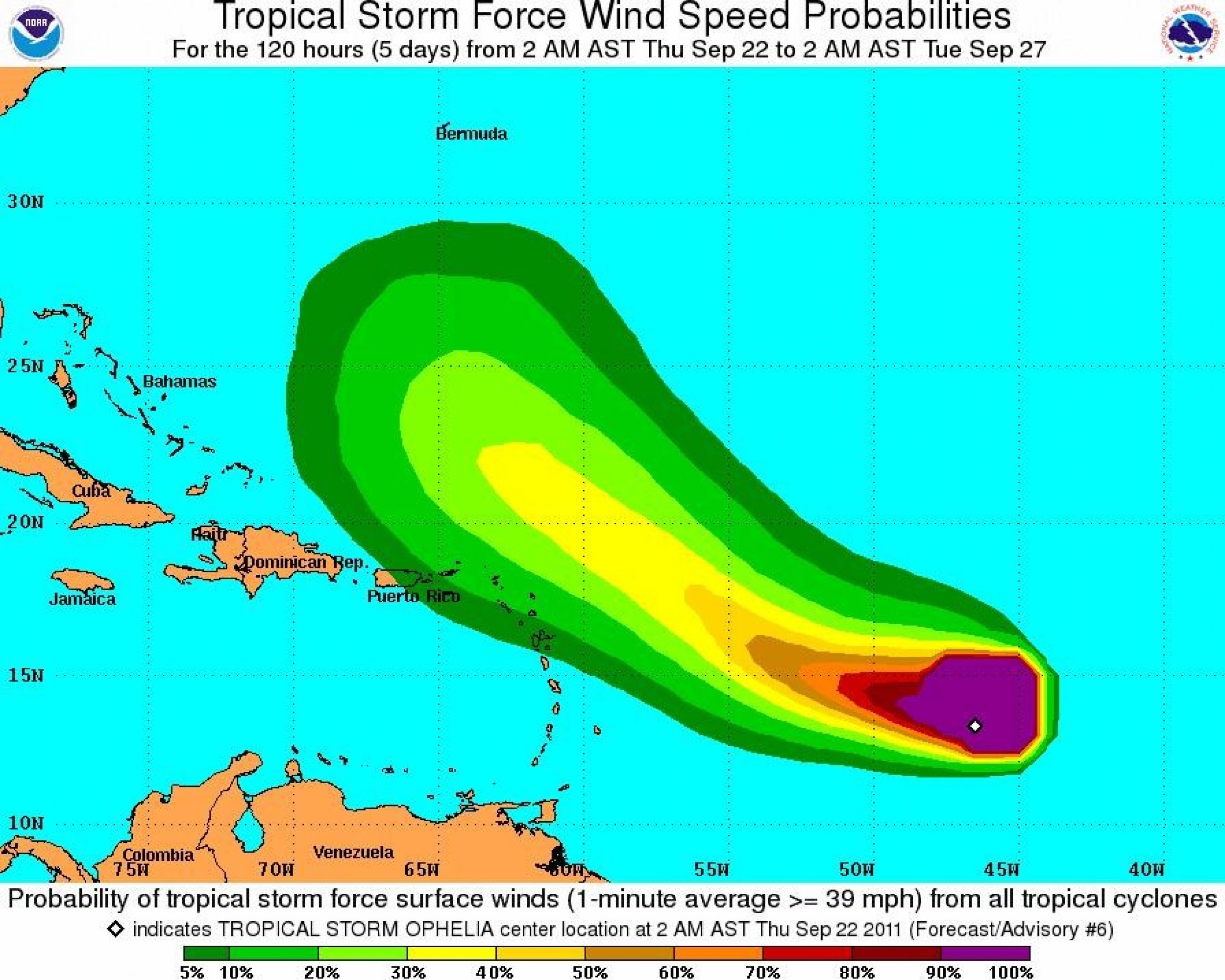
According to Thursday's 5 a.m. EDT alert from the National Hurricane Center in Miami, Ophelia is moving west at 14 mph with maximum sustained winds of 65 mph. The storm grew dramatically on Wednesday with tropical-storm-force winds now extending outward up to 230 miles from the storm center.
NOAA Buoy 41041 recently reported a hurricane-force wind gust of 78 mph.
Located about 1020 miles east-southeast of the Leeward Islands, Tropical Storm Ophelia is expected to continue moving west with a turn to the west-northwest on Friday. The storm is expected to weaken slightly during the next 48 hours due to strong upper-level winds.
On Ophelia's projected path, the storm should curve above the northern Leeward Islands on Sunday and be well north of Puerto Rico by Tuesday morning. It is still too soon to say what, if any, impact the storm will have on the United States' East Coast.
Though the storm is approaching hurricane-strength, forecasters do not think that Ophelia will become a hurricane anytime soon. Strong upper-level winds in Ophelia's path will make conditions unfavorable for strengthening and the NHC predicts that the system will remain a tropical storm through Tuesday.
It's going to keep chugging along for a day or two, NHC spokesman Dennis Felgen said. But it's probably strengthened just about as much as it can before it hits some real serious wind problems
Elsewhere in the Atlantic, a small area of low pressure located over the Mona Passage is producing scattered showers, thunderstorms, and locally heavy rains over Puerto Rico and the Dominican Republic. Upper-level winds are not conducive for development and the system has a very low chance of becoming a tropical cyclone.
The 15th named storm of the 2011 Atlantic hurricane season, Tropical Storm Ophelia comes not long after Tropical Storm Nate made landfall in Mexico earlier in the month, killing four people.
A revised outlook predicts 14 to 19 named storms this year, seven to ten of which are expected to become hurricanes. Three to five of those are expected to become major hurricanes of Category 3 or higher on the Saffir-Simpson Hurricane Wind Scale.
With over two months left in the hurricane season and 15 named storms already, it's turning out to be the atypically busy year that forecasters had predicted


© Copyright IBTimes 2024. All rights reserved.


