

Weather: Saola To Exit Philippines With Nearly 200K People Affected Amid Storm Haikui Entry

KEY POINTS
- Two areas are under TCWS No. 2, while several other parts of Luzon are under TCWS No. 1
- More than 35,000 people are in evacuation centers due to Saola
- Tropical storm Haikui is expected to enter the country Wednesday night
Super Typhoon Saola is expected to leave the Philippines by Thursday, with nearly 200,000 people affected as another storm, Haikui, is set to enter the Philippine Area of Responsibility (PAR).
In its latest weather report, the Philippine Atmospheric, Geophysical and Astronomical Services Administration (Pagasa) said heavy rainfall will continue to fall in the northern part of the country Wednesday due to Typhoon Saola, locally called Goring.
Gusty conditions are expected in the Ilocos Region, Cordillera Administrative Region, Bataan, Zambales, Aurora, Bulacan, Metro Manila, Western Visayas, Bicol Region, CALABARZON and MIMAROPA on Wednesday.
Goring is expected to leave PAR Wednesday night or Thursday morning. It is forecast to continue moving west-northwest before moving westward Friday and then west-southwest Saturday near the coast of Guangdong, China.
Officials noted that Saola has maximum sustained winds of 195 kmh (121 mph) and gustiness of up to 240 kmh (149 mph) as of Wednesday.
As of Wednesday morning, Tropical Cyclone Wind Signal (TCWS) No. 2 – winds up to 88 kmh or 54 mph – was hoisted in Batanes and the Babuyan Islands.
The following areas are under TCWS No. 1 (winds up to 61 kmh or 37 mph):
Ilocos Norte
Northern portion of Abra – Tineg, Lagayan and Danglas
Ilocos Sur – Sinait, San Juan and Cabugao
Apayao
Northern and central Cagayan – Amulung, Rizal, Santo Nino, Piat, Santa Ana, Lasam, Gattaran, Lal-Lo, Gonzaga, Baggao, Buguey, Santa Teresita, Aparri, Camalaniugan, Alcala, Santa Praxedes, Allacapan, Ballesteros, Abulug, Pamplona, Sanchez-Mira and Claveria
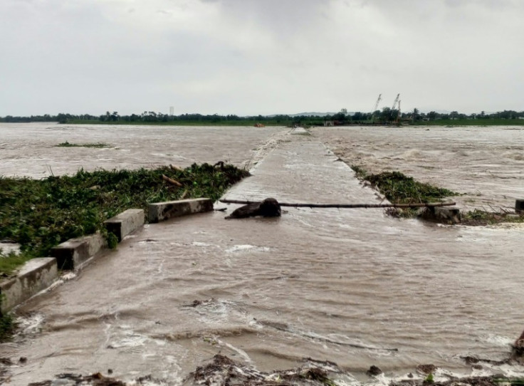
Saola, which was elevated to a super typhoon anew Tuesday, affected a total of 196,926 individuals as of Wednesday morning, according to data from the National Disaster Risk Reduction and Management Council (NDRRMC). More than 35,000 people have been moved to evacuation centers, and the typhoon has left 28 roads and 19 bridges unpassable.
So far, 134 houses have been reported damaged by the typhoon – 52 of which are totally damaged – and infrastructure damage has been estimated at P41.1 million (approximately $724,800).
Meanwhile, severe tropical storm Haikui is approaching PAR and is expected to enter the country Wednesday afternoon or Wednesday night, as per an advisory from Pagasa. Once it enters PAR, the storm will be called Hanna.
So far, Haikui has logged maximum sustained winds of 110 kmh (68 mph) near the center and gustiness of up to 135 kmh (83 mph). The weather agency noted that Haikui has "strong to storm-force winds" that extend outwards up to 300 km (186 miles) from the center.
The new tropical storm is forecast to reach maximum sustained winds of up to 150 kmh (93 mph) by Friday. It is expected to continuously intensify within the next five days, but current forecasts suggest Haikui will not directly affect the Philippines. It may still enhance the southwest monsoon starting Thursday, resulting in rains over the western part of Luzon and Visayas throughout the week.
© Copyright IBTimes 2024. All rights reserved.
-

Canada AI Project Hopes To Help Reverse Mass Insect Extinction
-

Aid Groups Express Horror At US Mines For Ukraine
-

As Trump Returns, China Seizes Chance For Climate Mantle
-

Taxing The Richest: What The G20 Decided
-

US Agency Opens Two Probes Into Ford Vehicles Amid Quality Control Concerns
-

Trump-Inspired Campaign Playbook? Polish Presidential Aspirant Vows To Turn Poland Into 'Crypto Haven'
-

Urban Mosquito Sparks Malaria Surge In East Africa
-

Sex, Drugs And Gritty Reality On Prague's Underworld Tours
-

Defiant Lebanese Harvest Olives In The Shadow Of War
-

'Critically Endangered' African Penguins Just Want Peace And Food


