

Weather Warning: 'Very Dangerous' Winter Conditions Expected In 4 States; 'Human Triggered' Avalanches Likely

KEY POINTS
- Avalanche danger is high in Colorado's mountain ranges through Saturday morning
- Up to 18 inches of snow accumulations is possible in some mountainous ranges in Utah
- 'Large and destructive' avalanches are possible in Nevada's Greater Lake Tahoe area
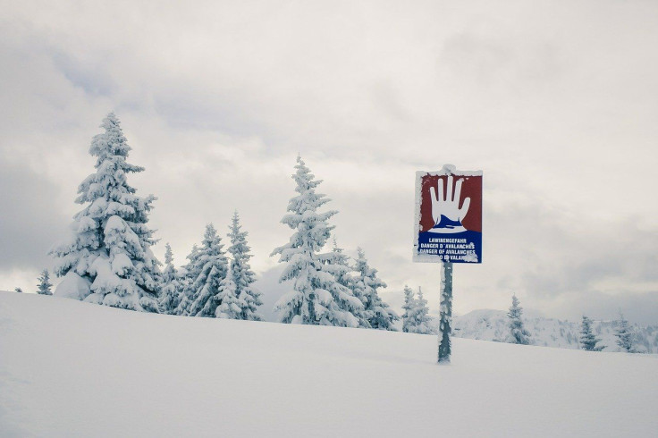
Weather forecasters have warned residents of "very dangerous avalanche conditions" in backcountry locations in Colorado, Utah, Nevada and Idaho. They have issued avalanche warnings, saying the danger is "high" in mountainous terrains.
"Very dangerous avalanche conditions and High (Level 4 of 5) avalanche danger from Friday morning through Saturday morning" in backcountry locations, the National Weather Service (NWS) in Boulder, Colorado, said in an alert.
The backcountry is described as "mountainous areas where the avalanche danger isn't managed or reduced as it would be at a ski area or on a highway," according to the Northwest Avalanche Center (NWAC).
Residents were told to "avoid travel on and under all steep slopes."
The NWS also noted strong winds and heavy snow "will result in widespread avalanche activity", adding "human-triggered avalanches are very likely."
Human-triggered avalanches start "when somebody walks or rides over a slab with an underlying weak layer," according to National Geographic. As the weak layer collapses, the overlaying snow mass begins to slide.
In northwestern Colorado and eastern Utah, wind gusts of 60 mph and up to 12 inches of snow accumulations are expected from Thursday evening through Friday.
A fast moving winter storm hits eastern Utah today moving into Colorado overnight. 6-12" snow possible in the central and northern mountains and about half that in the San Juans. Strong winds pick up overnight and Friday making travel difficult. #COwx #UTwx pic.twitter.com/kukb2DcPC1
— NWS Grand Junction (@NWSGJT) December 1, 2022
Up to 18 inches of snow accumulations are possible in the Provo and Park City area mountains in Utah.
For northern Utah valleys, though a lot of the snow will have already fallen before the commute, snow will remain on the roads in many locations, resulting in significant travel difficulties, particularly during the beginning of the commute. Delay travel if possible. #utwx pic.twitter.com/Vbez76FYPa
— NWS Salt Lake City (@NWSSaltLakeCity) December 1, 2022
The NWS said dangerous conditions can be triggered by a combination of very strong winds and "a rapid load of heavy snow" in areas where avalanche warnings were issued. "Some avalanches could be large and destructive" in the Greater Lake Tahoe area in Nevada.
Meteorologist Roland Steadham posted a photo of snow measurements in the Cascade area in Idaho where 15 inches of snow was recorded Thursday.
An amazing 15” of snow in Cascade with this storm and it’s still coming down! #idwx #letitsnow pic.twitter.com/3RdhhRsI6c
— Roland Steadham (@RolandKBOI) December 1, 2022
Avalanche warning in Colorado effective through 8 a.m. Saturday:
- Gore Range – Elk Mountains, West Elk Mountains, Central Mountain Valleys, Sawatch Mountains
Avalanche warning in Colorado effective through 5 a.m. Sunday:
- Park Range – Elkhead Mountains, Flat Tops, West Jackson Counties above 9,000 feet and West Grand Counties above 9,000 feet
Avalanche warning in Utah effective from 3 p.m. Friday through 6 a.m. Saturday:
- Northern Utah Mountains – Wasatch Mountains I-80 North, Wasatch Mountains South of I-80, Bear River Range and Western Uinta Range
Avalanche warning in Nevada effective through 7 p.m. Friday:
- Greater Lake Tahoe Area – Central Sierra Nevada Mountains between Yuba Pass on the north and Ebbetts Pass on the south
Avalanche warning in Idaho effective through 6 a.m. Saturday:
- Southeast Idaho - Bear River Range
The NWAC urged people to be alert and be prepared as the backcountry during winter "is a place where you need to be self-sufficient and prepared to manage a range of hazards, including avalanches."
© Copyright IBTimes 2024. All rights reserved.
- MOST POPULAR IN National


