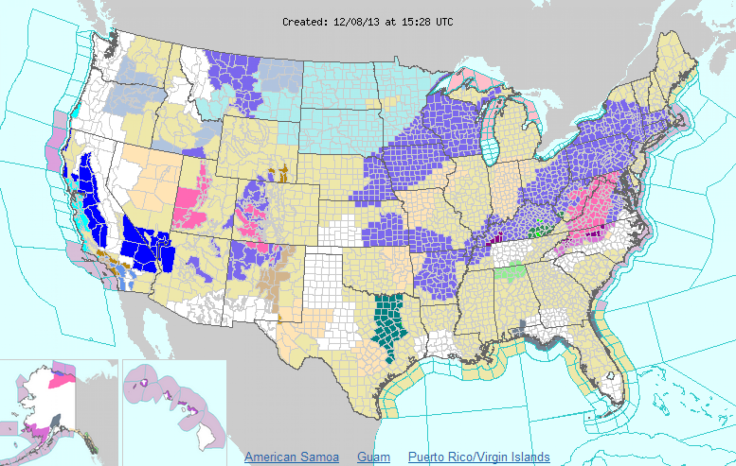
Winter Storm Dion Update: Wintry Mix Of Snow And Ice From Midwest To New England
Winter Storm Dion, as it is called by the Weather Channel, caused hundreds of delays and left thousands without power in the western United States. The weather system is traveling east and is expected to bring a mix of snow and ice to the Midwest, Ohio Valley, Middle Atlantic and Northeast, causing plenty problems for the start of the work week.

Previous reports indicate the weather played a role in the deaths of 11 individuals. On Saturday, Dion caused more than 300 flight cancellations at the Dallas/Fort Worth International Airport on Saturday and the wintry weather affected more than a dozen states. The storm has already produced snow in Washington and will continue to affect more states through Sunday and into Monday, reports the Weather Channel.
TWC reports large accumulations of ice could occur east of the Appalachians, including parts of Virginia, such as the Shenandoah Valley, Pennsylvania and North Carolina. Unsafe roads may lead due dangerous travel conditions and TWC reports Roanoke, Va., Hagerstown, Md. and Greensboro, N.C. may experience power outages due to Dion. Most of the Midwest is expected to light snow throughout Sunday. One to three inches is expected for the majority of affected states while eastern Nebraska, Iowa, Minnesota, Wisconsin and Upper Michigan may see between two to five inches of snow.
By Sunday night, Dion is expected to bring light snow to New York City, Boston, Washington D.C., Philadelphia, Baltimore and New England. The light snow will turn to rain for NYC, Baltimore and Philadelphia by midnight on Sunday, with Washington D.C. seeing rain late Sunday night, notes TWC. Light snow in Boston will turn to rain by Monday but northern New England and upstate New York are expected to see a mix of rain and snow. New Hampshire, northern Vermont and Maine are expected to see snow for most of Monday.
The National Weather Service's short range weather forecast for Sunday states, "Snow is expected from the Middle Missouri Valley into the Great Lakes. Snow will change over to freezing rain then to rain from parts of the Ohio/Tennessee Valleys to the Mid-Atlantic/Southern New England. Heavy rain possible from parts of the Lower Mississippi Valley/Central Gulf Coast to the Tennessee Valley."
For travelers at DFW Airport, there is some progress but the airport has announced the cancellation of 400 flights on Sunday. Ice has been cleared from three runways and the number of passengers staying at the airport has decreased, down from 3,000 to 2,076.
© Copyright IBTimes 2024. All rights reserved.


