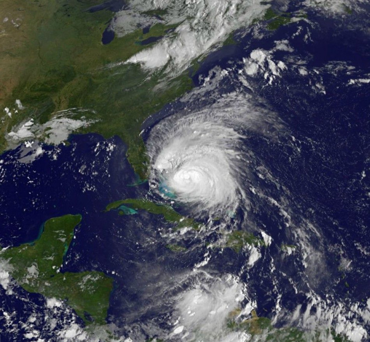
Hurricane Irene: A View From An Academic Expert

As Hurricane Irene barrels up the eastern seaboard of the U.S. – amidst expectations of widespread damage, arising from torrential rainfall, brutal gale-force winds and flash flooding from South Carolina to New England -- International Business Times spoke with a hurricane expert to discuss the 2011 hurricane season.
Hurricane season for the western Atlantic and the Gulf of Mexico runs from June 1 through November 30.
Corene Matyas is an assistant professor of geography at the University of Florida in Gainesville and an expert on hurricanes.
IB TIMES: It seems that hurricane activity in the Atlantic over the past three years has been rather quiet -- that is, I can recall no significant storms that made landfall in the U.S. and caused much damage over that period. Why was this?
MATYAS: It is important to remember that just because the U.S. has not experienced many landfalls or damage during 2009 and 2010 that does not mean that hurricane activity was reduced in the Atlantic basin.
In fact, 2010 is tied for third place for the number of named storms in a season, and it is tied for second place for the largest number of hurricanes.
Some of these storms did make landfall – for example, Mexico was hit very hard in 2010 [by hurricanes Alex and Karl].
The 2009 season did have below-normal activity, yet the U.S. still saw significant damage to beaches from Hurricane Bill even though it remained offshore.
IB TIMES: The last big flurry of devastating storms in the U.S. seemed to be in the summer of 2008 (Gustav, Ike). Are you expecting 2011 to be a big season for dangerous hurricanes?
MATYAS: Predictions issued by several groups call for 2011 to have more tropical cyclone activity than normal in the Atlantic basin. Irene is the ninth named storm of the season and is our first hurricane as well as first major hurricane (Category-3 or higher which features sustained winds of 111 miles per hour over a 1-minute period).
Activity tends to peak around September 10, and September is normally the most active month, so we are less than half-way through the season.
Regarding the dangers posed by hurricanes, it is important to remember that they pose risks to different groups of people at different times and places. For example, ships on the ocean face dangers even when storms do not approach land.
Intense storms such as Irene pose dangers to coastal communities in the form of rip currents even if they do not come close enough to shore to cause damage related to wind, surge, rainfall, or tornadoes.
In the relatively inactive 2009 season, Hurricane Bill stayed well offshore, but the wave energy it caused resulted in severe beach erosion along the Atlantic Coast, and several people died in the water.
IB TIMES: Does the frequency of powerful hurricanes have anything to do with the temperature of the ocean water?
MATYAS: The temperature of ocean water is not the only mechanism involved in creating hurricanes or controlling their intensity.
The evaporation of water from the ocean and then its condensation in the atmosphere is the main mechanism that provides energy for the storm.
However, evaporation and condensation rates are dependent upon the environment within which they occur.
Also, the environment within which the hurricane is contained can help or hinder storm development depending on variables such as the speed and direction of the winds surrounding the storm at different altitudes, the moisture content of the surrounding atmosphere, and the temperature structure of the atmosphere, among other factors.
Current and future projections of hurricane frequency or severity cannot be based on just one variable (i.e., global ocean temperatures) as this will lead to inaccurate results.
© Copyright IBTimes 2024. All rights reserved.


