

Hurricane Irma Images: What A Category 5 Storm Looks Like
The worst may be yet to come from Hurricane Irma, which has been churning over the Caribbean and powered up into a Category 5 storm. It is still going after wiping through Antigua and Barbuda, St. Martin and Anguilla, and St. Kitts and Nevis on its way to Puerto Rico and the Virgin Islands.
Most people who live through a hurricane see the storm from the ground, as it tears apart buildings and sends water rising into homes. From the air, however it looks completely different. Here are some images of Hurricane Irma from above to put the storm into perspective.
Stadium of clouds
The eye of a hurricane is a calm pillar through the center of the storm where few clouds penetrate — they simply swirl around it. From within that eye, the clouds can appear like they are rising in walls around it, forming a shape similar to a stadium. This sight has earned the name “the stadium effect.”
Irma has a well-defined eye through which pilots known as hurricane hunters from the National Oceanic and Atmospheric Administration and the U.S. Air Force Reserve have bravely flown to capture images of the hurricane. The stadium effect appeared intense this week.
The stadium effect is well defined in this image capture by one of our #ReserveCitizenAirmen during a flight into Cat 5 #hurricaneIrma pic.twitter.com/R2cFjy49LS
Inside the eye of #Irma on WP-3D Orion #NOAA42. This is referred to as the "stadium effect" https://t.co/iofV4p56DE Credit CDR Kibbey/NOAA. pic.twitter.com/dlUta2IbDL
That effect is apparent even in the dark, while the moon shines onto the cloud tops.
Another look at the moon inside #HurricaneIrma courtesy the @USAFReserve Hurricane Hunters. pic.twitter.com/7FzIKiG5S1
When looking down onto the hurricane, the bowl shape of the stadium effect is clearer.
Late afternoon sun casting a shadow on Hurricane #Irma's eye. #GOES16 pic.twitter.com/CQaSgHzVN6
Up above the world so high
From even higher up, satellites have a view of Hurricane Irma that makes the storm look tiny. But against the shape of Earth below it, the storm is a sight to behold.
Some satellites were watching before Irma smacked into the Leeward Islands.
Watch as Hurricane #Irma moves toward the Leeward Islands in this #GOES16 geocolor loop. Get the latest on Irma @ https://t.co/cSGOfrM0lG pic.twitter.com/ixIhkXqVNa
This is what it looked like as it made a beeline for the small island Anguilla.
#GOES16 captured this geocolor image of Hurricane #Irma approaching Anguilla at about 7:00 am (EDT). Latest info @ https://t.co/cSGOfrM0lG pic.twitter.com/R24P0Q1EPm
The International Space Station often captures images of hurricanes as they swirl through oceans, and Irma was no exception. The ISS took video of the storm as it hung heavily and obscured the water and land forms below it.
The International Space Station’s external cameras captured a dramatic view of Hurricane Irma as it moved across the Atlantic Ocean Sept. 5. pic.twitter.com/mc61pt2G8O
One part of the video that is particularly striking is when the space station’s external cameras cut to a view of the hurricane as a cargo spacecraft docked to the ship, part of the Russian fleet called Progress, photobombs it. Although the large piece of equipment is so close to the camera, the spacecraft still looks petite in comparison to the hurricane, which is a couple of hundred miles away.
Although it is unclear how far Hurricane Irma will go and how much damage the storm will cause, it is clear that it looks formidable.
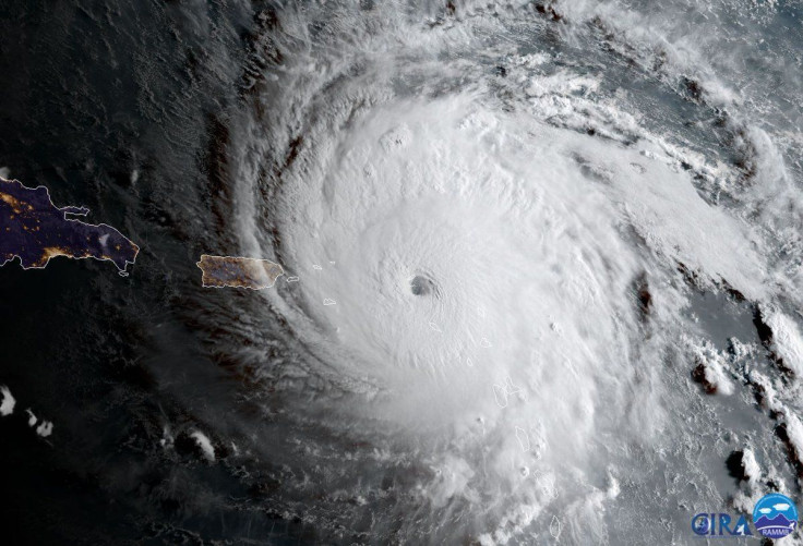
Get a good look at Hurricane #Irma's eye with this visible imagery from #GOES16! For the latest info on Irma, go to https://t.co/cSGOfrM0lG pic.twitter.com/q4Q5UtPlIP
— NOAA Satellites (@NOAASatellites) September 5, 2017
© Copyright IBTimes 2024. All rights reserved.
- MOST POPULAR IN World


