

Extremely Powerful Hurricane Milton Poses 'Extremely Serious Threat' To Florida
Tampa could experience 15 feet of water as a storm surge combines with high tides.


Hurricane Milton has weakened as it slowly tracks its way toward the Florida coast.
The National Hurricane Center said the storm's maximum sustained winds were an estimated 155 mph with higher gusts by early Tuesday morning.
Officials warn that the landfall of Milton could bring life-threatening hazards along portions of the coastline and poses an extremely serious threat to Florida.
The storm was about 85 miles Northeast of Progreso, Mexico and about 560 miles Southwest of Tampa at 5 a.m. EDT on Tuesday. It was moving about 12 mph.
After landfall, Milton is expected to weaken and head east across the state and into the Atlantic Ocean.
Florida authorities are preparing to order mass evacuations ahead of the storm.
Gov. Ron DeSantis expanded the state of emergency over the weekend.
"We now have a total of 51 Florida counties in a state of emergency," he said. "A major hurricane is the most likely outcome—this is not a good track for the state of Florida."
Long lines of cars have clogged roads leading out of the Tamba Bay area as people are heading calls to evacuate.
Kevin Guthrie, executive director for the Florida Division of Emergency Management, announced at a Sunday news conference that his team was preparing for "the largest evacuation that we have seen" since 2017's Hurricane Irma.
"Evacuate if you are in an evacuation zone. If you are not in an evacuation zone and your house was built in accordance with the Florida building code, you may be better off staying in place," he said. "If you are dependent on power, you will need to evacuate. If you're dependent on a special set of circumstances, you'll need to evacuate."
The storm comes on the heels of Hurricane Helene which battered the coast of Florida before turning north and causing significant damage to several other southern states.
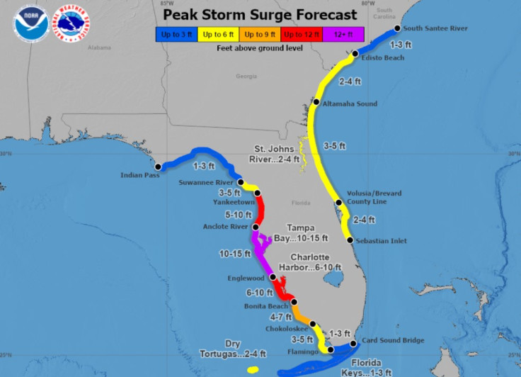
A storm surge will raise water levels by as much as 4 to 6 feet above ground level along the northern coast of the Yucatan Peninsula in areas of onshore winds. Near the coast, the surge will be accompanied by large and destructive waves.
The combination of the storm surge and the tide will cause normally dry areas near the coast to be flooded by rising waters moving inland from the shoreline. The water could reach the following heights above ground somewhere in the indicated areas if the peak surge occurs at the time of high tide.
Anclote River, FL to Englewood, FL...10-15 ft
Tampa Bay...10-15 ft
Englewood, FL to Bonita Beach, FL...6-10 ft
Charlotte Harbor...6-10 ft
Yankeetown, FL to Anclote River, FL...5-10 ft
Bonita Beach, FL to Chokoloskee, FL...4-7 ft
Suwannee River, FL to Yankeetown, FL...3-5 ft
Chokoloskee, FL to Flamingo, FL...3-5 ft
Flagler/Volusia County Line, FL to Altamaha Sound, GA...3-5 ft
Sebastian Inlet, FL to Flagler/Volusia County Line, FL...2-4 ft
Altamaha Sound, GA to Edisto Beach, SC...2-4 ft
Dry Tortugas...2-4 ft
St. Johns River...2-4 ft
Hurricane Milton Timeline
Milton is moving toward the east-northeast near 12 mph. A turn toward the east-northeast and northeast is expected today and Wednesday. On the forecast track, the center of Milton is forecast to move just north of the Yucatan Peninsula today and approach the west coast of the Florida Peninsula on Wednesday. The hurricane is forecast to make landfall in Florida Wednesday night.
While fluctuations in intensity are expected, Milton is forecast to remain an extremely dangerous hurricane through landfall in Florida.
Hurricane-force winds extend outward up to 30 miles from the center and tropical-storm-force winds extend outward up to 105 miles.
Hurricane Milton Watches and Warnings
A Storm Surge Warning is in effect for...
* West coast of Florida from Flamingo northward to the Suwannee
River, including Charlotte Harbor and Tampa Bay
A Hurricane Warning is in effect for...
* Celestun to Rio Lagartos
* Florida west coast from Bonita Beach northward to the mouth of the
Suwannee River, including Tampa Bay
A Storm Surge Watch is in effect for...
* Sebastian Inlet to Edisto Beach, including St. Johns River
A Hurricane Watch is in effect for...
* Rio Lagartos to Cabo Catoche
* Campeche to south of Celestun
* Dry Tortugas
* Lake Okeechobee
* Florida west coast from Chokoloskee to south of Bonita Beach
* Florida east coast from the St. Lucie/Indian River County Line
northward to the mouth of the St. Marys River
A Tropical Storm Warning is in effect for...
* Rio Lagartos to Cancun
* Campeche to south of Celestun
* All of the Florida Keys, including Dry Tortugas
* Lake Okeechobee
* Florida west coast from Flamingo to south of Bonita Beach
* Florida west coast from north of the mouth of the Suwanee River to
Indian Pass
A Tropical Storm Watch is in effect for...
* East coast of the Florida Peninsula south of the St. Lucie/Indian
River County Line southward to Flamingo
* Coast of Georgia and South Carolina from north of the mouth of the
St. Marys River to South Santee River, South Carolina
© Copyright IBTimes 2024. All rights reserved.
- MOST POPULAR IN U.S.


