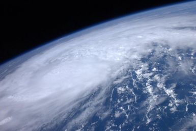
In a bid to get ahead of Hurricane Irene that threatens to thrash the U.S. East Coast, New York declares a state of emergency, becoming the fifth state to do so.
Hurricane Irene has caused the indefinite postponement of the dedication of the Martin Luther King Jr. Memorial that was slated for Sunday.
A strengthening Hurricane Irene continues to move towards the U.S. East Coast, destroying some islands in the Bahamas along its path as it heads for the big cities. New York is the latest of five states to declare a state of emergency.
Ocean City activated phase three of its hurricane action plan and saw the evacuation of thousands of residents and visitors as officials made strict orders following Hurricane Irene's expected hit at the Maryland shore, while danger warnings were issued by Gov. Martin O'Malley of the monster storm.
Hurricane Irene is gearing up to be the biggest storm threatening to hit the New York metropolitan area in 26 years. Should Irene make landfall on Sunday with hurricane strength, it will be one of about five storms that have come within 75 miles of the city, according to data dating to 1851.
Hurricane Irene could end up closing refineries on the East Coast, which are concentrated in New Jersey and Pennsylvania, in anticipation for the storm's arrival, analysts say. Irene has been putting a beating down on the Bahamas for about two days. Structural damages, blocked roads and power outages have been reported in the southeastern islands.
Category 3 Hurricane Irene is gaining momentum and seemingly heading right for the city that never sleeps, and the potential exists -- in addition to risks to human life -- for major damage to New York's dwellings/infrastructure and economy.
Irene is expected to pass through Western Mass. Sunday night into Monday
Officials in Ocean City, Md. have ordered residents to evacuate after the swiftly approaching Hurricane Irene led Maryland Gov. Martin O'Malley to declare a state of emergency.
Hurricane Irene continued its path of destruction towards the East Coast on Thursday -- posing extreme danger to some of the country's largest cities.
New Yorkers are preparing for Hurricane Irene, which threatens to become one of the biggest storms to hit the metropolitan area in decades. If Irene makes landfall in the New York area at hurricane strength, the powerful storm would be one of about five hurricanes to come within 75 miles of the city, according to records dating back 160 years.
Hurricane Irene poses an extraordinary threat to virtually upper half of the U.S. East Coast, threatening to become a storm of a lifetime. The major Category 3 storm has the potential to further strengthen before making landfall, and major metropolitan areas from Norfolk to New York and Boston face a threat of rare storm potency.
Hurricane Irene is expected to reach parts of Eastern Canada over the weekend.
As Hurricane Irene batters the northern Bahamas on as it heads toward the East Coast on Thursday, train services were canceled and workers scrambled to protect power lines in the U.S. capital, Washington D.C.
Irene is expected to make landfall in New Jersey on Sunday morning as a Category 2 hurricane, with sustained winds between 96 and 110 miles per hour. Experts say it could be the worst storm ever to hit New Jersey.
Officials have stated that the voluntary order could soon be changed into a mandatory one.
Hurricane Irene is shaping up to be the U.S. east coast storm of a lifetime. Officials say Irene poses an extreme threat to areas from North Carolina to to southern New England through the end of the weekend. The major Category 3 storm has the potential to further strengthen before making landfall, and major metropolitan areas from Norfolk to New York and Boston face a threat of rare storm potency.
Hurricane Irene is not the first hurricane with that name. Here's a look of a few of the past Irenes.
The 115 mph Category 3 storm is expected to hit North Carolina's Outer Banks Saturday afternoon. The hurricane will then creepy up the Eastern Seaboard.
While no one can know ahead of time just how much destruction a Category 3 Hurricane like Irene will do, specialty companies that specialize in catastrophic risk analysis are armed with historical data as well as links to national computer centers that track the storm in real time.
The Hurricane Irene Tracking maps from the National Hurricane Center (NHC) show that winds are expected to engulf big chunks of the East Coast.
As Hurricane Irene approaches the East Coast, Airlines began issuing travel waivers and cancelling flights.


