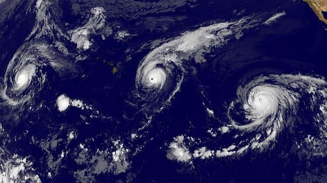
NASA Image Shows 3 Hurricanes Approaching Toward Pacific As Big Island of Hawaii Braces For High Winds

Three Category 4 hurricanes are approaching the Pacific Ocean, according to a new image captured by the National Oceanic and Atmospheric Administration satellite. All the three hurricanes -- named Hurricane Kilo, Hurricane Ignacio and Hurricane Jimena -- are approaching the ocean at the same time.
The image of the three hurricanes marching toward the Pacific was recently released by NASA. Although the image appears to be serene, its clarity depicts the massive amount of threat that the situation poses to Japan, Hawaii, Taiwan and the Philippines. According to the U.S. Weather Channel, this is the first time in the history that three hurricanes are approaching at the same time have been captured by a satellite.
While Hurricane Ignacio is expected to hit the north of Hawaii in the first week of September, the island has started to take the preparedness steps to brave the high winds. The approach of the hurricane is likely to bring high rainfall and a six-meter rise in the level of the ocean surrounding the state.
Hurricane Jimena is expected to pass through a little far from Hawaii during the mid of the first week of September. However, experts are not sure about the path of the hurricane and say that it might actually deviate from what is being forecast. On the other hand, Hurricane Kilo will also remain one of the major hurricanes during the week; however, it is safely located in the open water.
The appearance of the three hurricanes together has been linked to the El Nino effect. According to The Australian Bureau of Meteorology, a one-degree higher temperature than the average has been recorded in the eastern half of the northern Pacific ocean and also the Indian ocean. In the coming weeks, the temperature is expected to increase even higher than the peak anomaly temperature observed during 2002 and 2009 El Nino.
© Copyright IBTimes 2024. All rights reserved.


