Even if Irene reaches New York as a weakened Category 1 or Category 2 hurricane, it could still wreak havoc because the city is simply not prepared to handle such storms the way Florida or the Gulf Coast are. In a worst-case scenario, here are the top five threats New York City would face from a major hurricane.
The historic earthquake caused a historic damage as it shook the nation's capital.While the mess around Washington, D.C. is being cleaned up on Wednesday, the Washington Monument in the heart of the city remained encircled within a black fence - due to a crack caused by Tuesday's 5.8-magnitude earthquake centered in Virginia.
Despite the entire hullabaloo surrounding the historic East Coast earthquake, the 5.8 magnitude quake didn't create that much economic damage.
While preparing for a major hurricane, the U.S. has seen an unusual amount of earthquake activity this week
Photos of engineers surveying the damage to a cherished national monument
Rumors of the couple's split continue to swirl around Hollywood and beyond.
A 7.0-magnitude earthquake hit a remote Amazon region of Peru on Wednesday, reports Reuters.
On Tuesday, the day the earthquake struck the east coast of the U.S., there were at least 30 seismic actions around the world of at least magnitude-2.5.
The 5.8 magnitude earthquake that rippled through Washington, D.C. on Tuesday cracked the Washington monument and broke loose pieces of the National Cathedral, leading authorities to close the two symbolically and architecturally significant sites.
Robertson, a native of Virginia, the epicenter of the quake, has long associated natural disasters with the ‘end of times’ and prophecies in the Bible.
The earthquake reminded us that we’ve got to be prepared for a variety of things.
Tuesday's shake-up also affected apes, snakes and beavers at the National Zoo.
Powerful Hurricane Irene could pose a big threat to the densely populated northeast United States, including New York, as it swings up the eastern seaboard from Saturday on its current forecast track, the top U.S. government hurricane forecaster said on Wednesday.
The earthquake that rocked the East Coast Tuesday was highly unusual, seismologists said. The 5.9 magnitude earthquake impacted the Carolinas to New England. The earthquake's epicenter was in central Virginia, the U.S. Geological Survey said, adding that Central Virginia is a seismic zone.
The Virginia earthquake sends a warning as many as 10 U.S. nuclear plants need to be checked
Many residents of Washington, D.C. and New York City initially thought that Tuesday’s earthquake was a tremor caused by a terrorist attack.
Six schools in Louisa County will reopen the day after Labor Day.
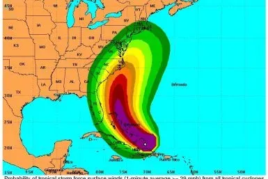
Hurricane Irene became a major storm on Wednesday, upgraded to Category 3 as it battered parts of the Bahamas with 115-mile-per hour winds and took aim on the New York area. Forecast models show a high threat level for eastern North Carolina to New England, and models showed Long Island holds potential for a direct strike.
Earthquakes are far more common than most Americans are aware
Hurricane Irene strengthened to a major Category 3 hurricane over the Bahamas on Wednesday as it roared up from the Caribbean on a path expected to swipe the East Coast from the Carolinas upward at the weekend.
You can be rest assured that the earthquake-hit Washington Monument is not tilting. However, a closer look at the world's tallest obelisk brought National Park Service officials to discover some cracks near the top of the 555-foot monument.
A strong earthquake rattled the East Coast on Tuesday, sending tremors as far as Canada, damaging well-known buildings in the nation's capital and sending scared office workers into the streets.


![East Coast Earthquake: 5.9 Quake Rocks NYC to Virginia: USGS [PHOTOS]](https://d.ibtimes.com/en/full/50418/east-coast-earthquake-59-quake-rocks-nyc-virginia-usgs-photos.webp?w=385&h=257&f=efb6982393f7e927fe27691c452df274)


